You are here: Home > Network List > TA - USArray Transportable Network (new EarthScope stations) Stations List
> Station Z47A Carrollton, AL, USA > Earthquake Result Viewer
Z47A Carrollton, AL, USA - Earthquake Result Viewer

| Earthquake location: |
Near East Coast Of Kamchatka |
| Earthquake latitude/longitude: |
57.6/163.2 |
| Earthquake time(UTC): |
2012/06/24 (176) 03:15:01 GMT |
| Earthquake Depth: |
10 km |
| Earthquake Magnitude: |
5.8 MB, 5.8 MS, 6.0 MW, 6.1 MW |
| Earthquake Catalog/Contributor: |
WHDF/NEIC |
|
| Network: |
TA USArray Transportable Network (new EarthScope stations) |
| Station: |
Z47A Carrollton, AL, USA |
| Lat/Lon: |
33.20 N/88.07 W |
| Elevation: |
65 m |
|
| Distance: |
71.7 deg |
| Az: |
56.762 deg |
| Baz: |
327.516 deg |
| Ray Param: |
0.054164007 |
| Estimated Moho Depth: |
63.5 km |
| Estimated Crust Vp/Vs: |
2.08 |
| Assumed Crust Vp: |
6.201 km/s |
| Estimated Crust Vs: |
2.981 km/s |
| Estimated Crust Poisson's Ratio: |
0.35 |
|
| Radial Match: |
84.567986 % |
| Radial Bump: |
400 |
| Transverse Match: |
74.73543 % |
| Transverse Bump: |
400 |
| SOD ConfigId: |
462790 |
| Insert Time: |
2013-02-12 18:02:20.820 +0000 |
| GWidth: |
2.5 |
| Max Bumps: |
400 |
| Tol: |
0.001 |
|
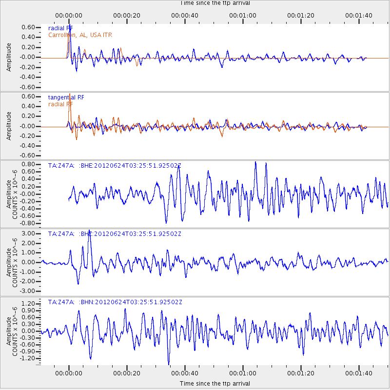
Signal To Noise
| Channel | StoN | STA | LTA |
| TA:Z47A: :BHZ:20120624T03:25:51.92502Z | 9.770654 | 9.757748E-7 | 9.986791E-8 |
| TA:Z47A: :BHN:20120624T03:25:51.92502Z | 3.1877022 | 3.9919078E-7 | 1.2522838E-7 |
| TA:Z47A: :BHE:20120624T03:25:51.92502Z | 2.4172645 | 3.1190396E-7 | 1.290318E-7 |
| Arrivals |
| Ps | 11 SECOND |
| PpPs | 31 SECOND |
| PsPs/PpSs | 42 SECOND |


