You are here: Home > Network List > TA - USArray Transportable Network (new EarthScope stations) Stations List
> Station P39B Salisbury, MO, USA > Earthquake Result Viewer
P39B Salisbury, MO, USA - Earthquake Result Viewer
| Earthquake location: |
Near East Coast Of Kamchatka |
| Earthquake latitude/longitude: |
57.6/163.2 |
| Earthquake time(UTC): |
2012/06/24 (176) 03:15:01 GMT |
| Earthquake Depth: |
10 km |
| Earthquake Magnitude: |
5.8 MB, 5.8 MS, 6.0 MW, 6.1 MW |
| Earthquake Catalog/Contributor: |
WHDF/NEIC |
|
| Network: |
TA USArray Transportable Network (new EarthScope stations) |
| Station: |
P39B Salisbury, MO, USA |
| Lat/Lon: |
39.49 N/92.75 W |
| Elevation: |
226 m |
|
| Distance: |
64.4 deg |
| Az: |
56.371 deg |
| Baz: |
324.6 deg |
| Ray Param: |
0.058966704 |
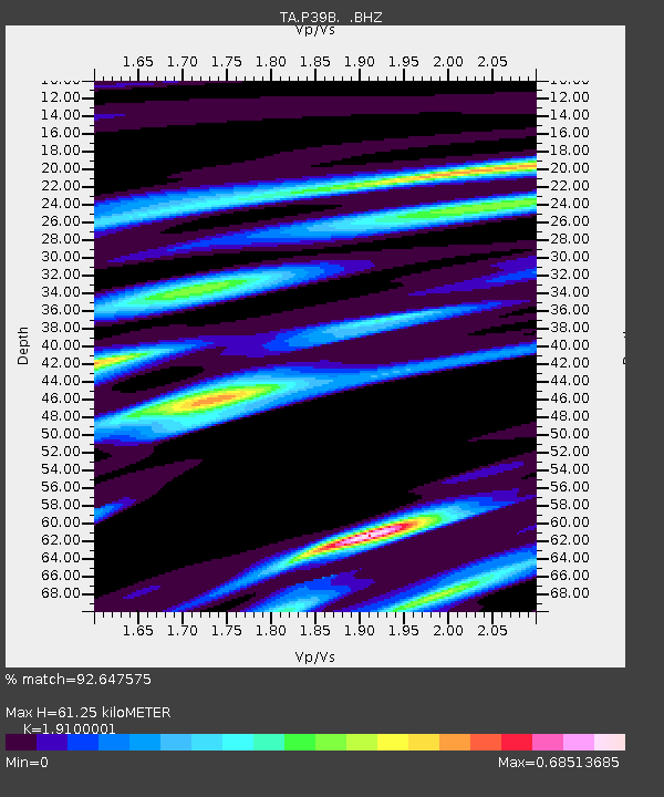
| Estimated Moho Depth: |
61.25 km |
| Estimated Crust Vp/Vs: |
1.91 |
| Assumed Crust Vp: |
6.498 km/s |
| Estimated Crust Vs: |
3.402 km/s |
| Estimated Crust Poisson's Ratio: |
0.31 |
|
| Radial Match: |
92.647575 % |
| Radial Bump: |
320 |
| Transverse Match: |
67.1285 % |
| Transverse Bump: |
400 |
| SOD ConfigId: |
462790 |
| Insert Time: |
2013-02-12 18:03:44.057 +0000 |
| GWidth: |
2.5 |
| Max Bumps: |
400 |
| Tol: |
0.001 |
|

Signal To Noise
| Channel | StoN | STA | LTA |
| TA:P39B: :BHZ:20120624T03:25:06.05002Z | 12.6950655 | 8.439898E-7 | 6.6481725E-8 |
| TA:P39B: :BHN:20120624T03:25:06.05002Z | 4.1665754 | 3.3738357E-7 | 8.097383E-8 |
| TA:P39B: :BHE:20120624T03:25:06.05002Z | 3.2046974 | 2.9810275E-7 | 9.302056E-8 |
| Arrivals |
| Ps | 8.9 SECOND |
| PpPs | 26 SECOND |
| PsPs/PpSs | 35 SECOND |


