You are here: Home > Network List > TA - USArray Transportable Network (new EarthScope stations) Stations List
> Station W44A Shelby Farms Park, Memphis, TN, USA > Earthquake Result Viewer
W44A Shelby Farms Park, Memphis, TN, USA - Earthquake Result Viewer
| Earthquake location: |
Near East Coast Of Kamchatka |
| Earthquake latitude/longitude: |
57.6/163.2 |
| Earthquake time(UTC): |
2012/06/24 (176) 03:15:01 GMT |
| Earthquake Depth: |
10 km |
| Earthquake Magnitude: |
5.8 MB, 5.8 MS, 6.0 MW, 6.1 MW |
| Earthquake Catalog/Contributor: |
WHDF/NEIC |
|
| Network: |
TA USArray Transportable Network (new EarthScope stations) |
| Station: |
W44A Shelby Farms Park, Memphis, TN, USA |
| Lat/Lon: |
35.14 N/89.82 W |
| Elevation: |
101 m |
|
| Distance: |
69.3 deg |
| Az: |
56.935 deg |
| Baz: |
326.597 deg |
| Ray Param: |
0.05575755 |
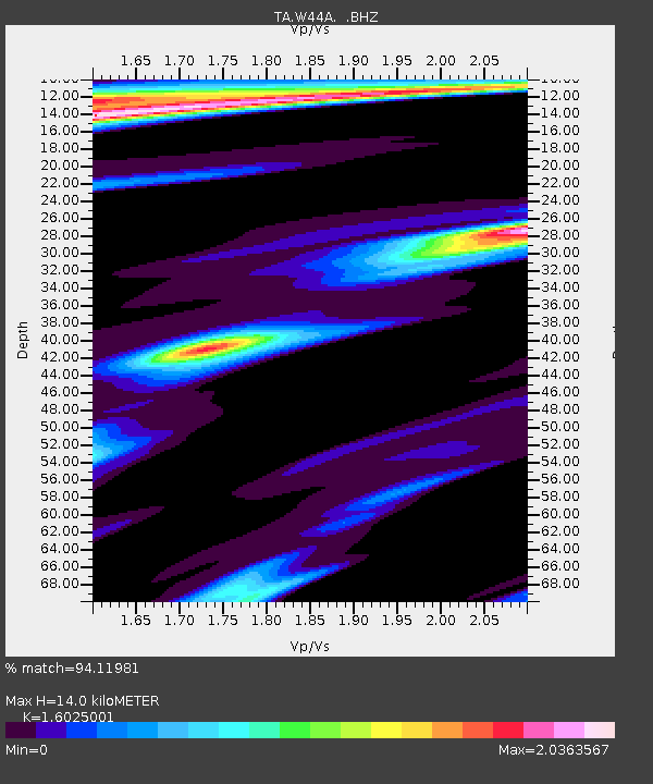
| Estimated Moho Depth: |
14.0 km |
| Estimated Crust Vp/Vs: |
1.60 |
| Assumed Crust Vp: |
6.38 km/s |
| Estimated Crust Vs: |
3.982 km/s |
| Estimated Crust Poisson's Ratio: |
0.18 |
|
| Radial Match: |
94.11981 % |
| Radial Bump: |
304 |
| Transverse Match: |
80.07148 % |
| Transverse Bump: |
389 |
| SOD ConfigId: |
462790 |
| Insert Time: |
2013-02-12 18:04:53.918 +0000 |
| GWidth: |
2.5 |
| Max Bumps: |
400 |
| Tol: |
0.001 |
|

Signal To Noise
| Channel | StoN | STA | LTA |
| TA:W44A: :BHZ:20120624T03:25:37.249971Z | 5.0496435 | 1.3431247E-6 | 2.6598406E-7 |
| TA:W44A: :BHN:20120624T03:25:37.249971Z | 1.9007915 | 6.4211315E-7 | 3.3781356E-7 |
| TA:W44A: :BHE:20120624T03:25:37.249971Z | 1.9721022 | 6.254563E-7 | 3.171521E-7 |
| Arrivals |
| Ps | 1.4 SECOND |
| PpPs | 5.5 SECOND |
| PsPs/PpSs | 6.9 SECOND |


