You are here: Home > Network List > TA - USArray Transportable Network (new EarthScope stations) Stations List
> Station W45A Hickory Valley, TN, USA > Earthquake Result Viewer
W45A Hickory Valley, TN, USA - Earthquake Result Viewer
| Earthquake location: |
Near East Coast Of Kamchatka |
| Earthquake latitude/longitude: |
57.6/163.2 |
| Earthquake time(UTC): |
2012/06/24 (176) 03:15:01 GMT |
| Earthquake Depth: |
10 km |
| Earthquake Magnitude: |
5.8 MB, 5.8 MS, 6.0 MW, 6.1 MW |
| Earthquake Catalog/Contributor: |
WHDF/NEIC |
|
| Network: |
TA USArray Transportable Network (new EarthScope stations) |
| Station: |
W45A Hickory Valley, TN, USA |
| Lat/Lon: |
35.16 N/89.19 W |
| Elevation: |
187 m |
|
| Distance: |
69.5 deg |
| Az: |
56.463 deg |
| Baz: |
326.793 deg |
| Ray Param: |
0.055579145 |
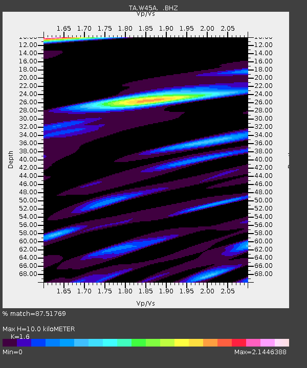
| Estimated Moho Depth: |
10.0 km |
| Estimated Crust Vp/Vs: |
1.60 |
| Assumed Crust Vp: |
6.38 km/s |
| Estimated Crust Vs: |
3.988 km/s |
| Estimated Crust Poisson's Ratio: |
0.18 |
|
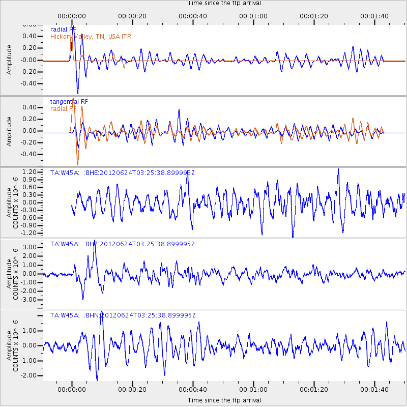
| Radial Match: |
87.51769 % |
| Radial Bump: |
400 |
| Transverse Match: |
79.367615 % |
| Transverse Bump: |
400 |
| SOD ConfigId: |
462790 |
| Insert Time: |
2013-02-12 18:05:41.887 +0000 |
| GWidth: |
2.5 |
| Max Bumps: |
400 |
| Tol: |
0.001 |
|
Signal To Noise
| Channel | StoN | STA | LTA |
| TA:W45A: :BHZ:20120624T03:25:38.899995Z | 11.199028 | 1.0180615E-6 | 9.090624E-8 |
| TA:W45A: :BHN:20120624T03:25:38.899995Z | 1.5674317 | 4.5501562E-7 | 2.9029374E-7 |
| TA:W45A: :BHE:20120624T03:25:38.899995Z | 1.1502583 | 3.8445322E-7 | 3.3423208E-7 |
| Arrivals |
| Ps | 1.0 SECOND |
| PpPs | 3.9 SECOND |
| PsPs/PpSs | 4.9 SECOND |


