You are here: Home > Network List > G - GEOSCOPE Stations List
> Station SSB Saint Sauveur Badole, France > Earthquake Result Viewer
SSB Saint Sauveur Badole, France - Earthquake Result Viewer
| Earthquake location: |
Andreanof Islands, Aleutian Is. |
| Earthquake latitude/longitude: |
50.5/-174.8 |
| Earthquake time(UTC): |
1992/08/19 (232) 00:57:43 GMT |
| Earthquake Depth: |
33 km |
| Earthquake Magnitude: |
6.1 MB, 5.7 MS, 5.6 ML |
| Earthquake Catalog/Contributor: |
WHDF/NEIC |
|
| Network: |
G GEOSCOPE |
| Station: |
SSB Saint Sauveur Badole, France |
| Lat/Lon: |
45.28 N/4.54 E |
| Elevation: |
700 m |
|
| Distance: |
84.6 deg |
| Az: |
0.434 deg |
| Baz: |
359.607 deg |
| Ray Param: |
0.04530708 |
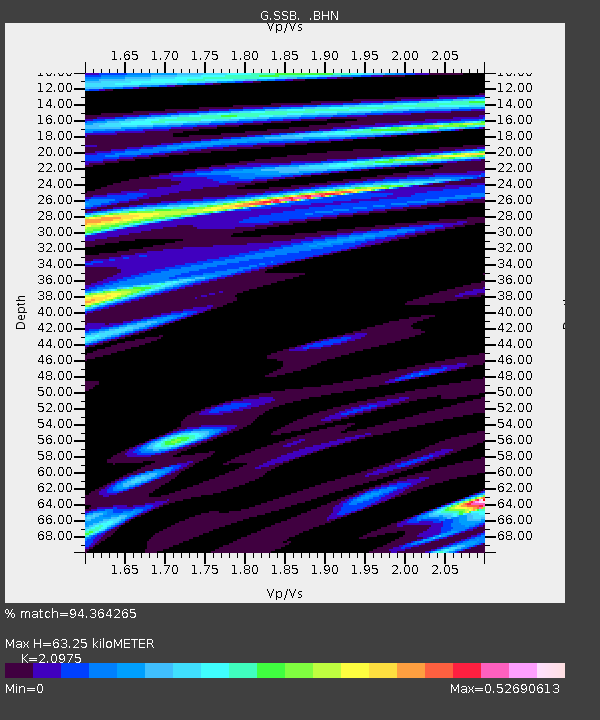
| Estimated Moho Depth: |
63.25 km |
| Estimated Crust Vp/Vs: |
2.10 |
| Assumed Crust Vp: |
6.1 km/s |
| Estimated Crust Vs: |
2.908 km/s |
| Estimated Crust Poisson's Ratio: |
0.35 |
|
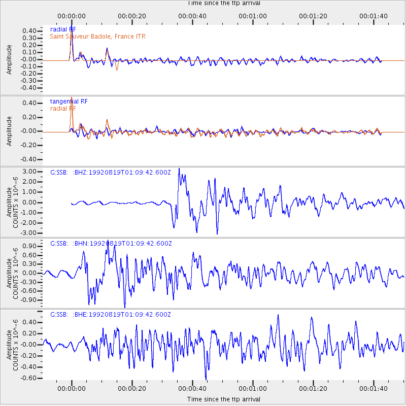
| Radial Match: |
94.364265 % |
| Radial Bump: |
400 |
| Transverse Match: |
85.701324 % |
| Transverse Bump: |
400 |
| SOD ConfigId: |
16938 |
| Insert Time: |
2010-02-27 00:07:07.900 +0000 |
| GWidth: |
2.5 |
| Max Bumps: |
400 |
| Tol: |
0.001 |
|
Signal To Noise
| Channel | StoN | STA | LTA |
| G:SSB: :BHN:19920819T01:09:42.600Z | 5.2918067 | 2.9799958E-7 | 5.6313393E-8 |
| G:SSB: :BHE:19920819T01:09:42.600Z | 1.1555127 | 7.5903834E-8 | 6.568845E-8 |
| G:SSB: :BHZ:19920819T01:09:42.600Z | 9.249787 | 9.0090595E-7 | 9.739747E-8 |
| Arrivals |
| Ps | 12 SECOND |
| PpPs | 32 SECOND |
| PsPs/PpSs | 43 SECOND |


