You are here: Home > Network List > TA - USArray Transportable Network (new EarthScope stations) Stations List
> Station L41A Preston, IA, USA > Earthquake Result Viewer
L41A Preston, IA, USA - Earthquake Result Viewer
| Earthquake location: |
Near East Coast Of Kamchatka |
| Earthquake latitude/longitude: |
57.6/163.2 |
| Earthquake time(UTC): |
2012/06/24 (176) 03:15:01 GMT |
| Earthquake Depth: |
10 km |
| Earthquake Magnitude: |
5.8 MB, 5.8 MS, 6.0 MW, 6.1 MW |
| Earthquake Catalog/Contributor: |
WHDF/NEIC |
|
| Network: |
TA USArray Transportable Network (new EarthScope stations) |
| Station: |
L41A Preston, IA, USA |
| Lat/Lon: |
42.08 N/90.50 W |
| Elevation: |
238 m |
|
| Distance: |
63.3 deg |
| Az: |
53.146 deg |
| Baz: |
324.645 deg |
| Ray Param: |
0.059697125 |
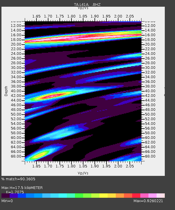
| Estimated Moho Depth: |
17.5 km |
| Estimated Crust Vp/Vs: |
1.71 |
| Assumed Crust Vp: |
6.53 km/s |
| Estimated Crust Vs: |
3.825 km/s |
| Estimated Crust Poisson's Ratio: |
0.24 |
|
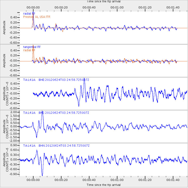
| Radial Match: |
90.3605 % |
| Radial Bump: |
400 |
| Transverse Match: |
72.4322 % |
| Transverse Bump: |
400 |
| SOD ConfigId: |
462790 |
| Insert Time: |
2013-02-12 18:06:53.666 +0000 |
| GWidth: |
2.5 |
| Max Bumps: |
400 |
| Tol: |
0.001 |
|
Signal To Noise
| Channel | StoN | STA | LTA |
| TA:L41A: :BHZ:20120624T03:24:58.725007Z | 10.856259 | 6.743886E-7 | 6.2119796E-8 |
| TA:L41A: :BHN:20120624T03:24:58.725007Z | 3.52403 | 2.6690176E-7 | 7.573766E-8 |
| TA:L41A: :BHE:20120624T03:24:58.725007Z | 3.9390562 | 2.3224311E-7 | 5.8959078E-8 |
| Arrivals |
| Ps | 2.0 SECOND |
| PpPs | 6.9 SECOND |
| PsPs/PpSs | 8.9 SECOND |


