You are here: Home > Network List > TA - USArray Transportable Network (new EarthScope stations) Stations List
> Station O41A Passley's Farm, La Prairie, IL, USA > Earthquake Result Viewer
O41A Passley's Farm, La Prairie, IL, USA - Earthquake Result Viewer
| Earthquake location: |
Near East Coast Of Kamchatka |
| Earthquake latitude/longitude: |
57.6/163.2 |
| Earthquake time(UTC): |
2012/06/24 (176) 03:15:01 GMT |
| Earthquake Depth: |
10 km |
| Earthquake Magnitude: |
5.8 MB, 5.8 MS, 6.0 MW, 6.1 MW |
| Earthquake Catalog/Contributor: |
WHDF/NEIC |
|
| Network: |
TA USArray Transportable Network (new EarthScope stations) |
| Station: |
O41A Passley's Farm, La Prairie, IL, USA |
| Lat/Lon: |
40.12 N/90.88 W |
| Elevation: |
203 m |
|
| Distance: |
64.7 deg |
| Az: |
54.665 deg |
| Baz: |
325.06 deg |
| Ray Param: |
0.05876313 |
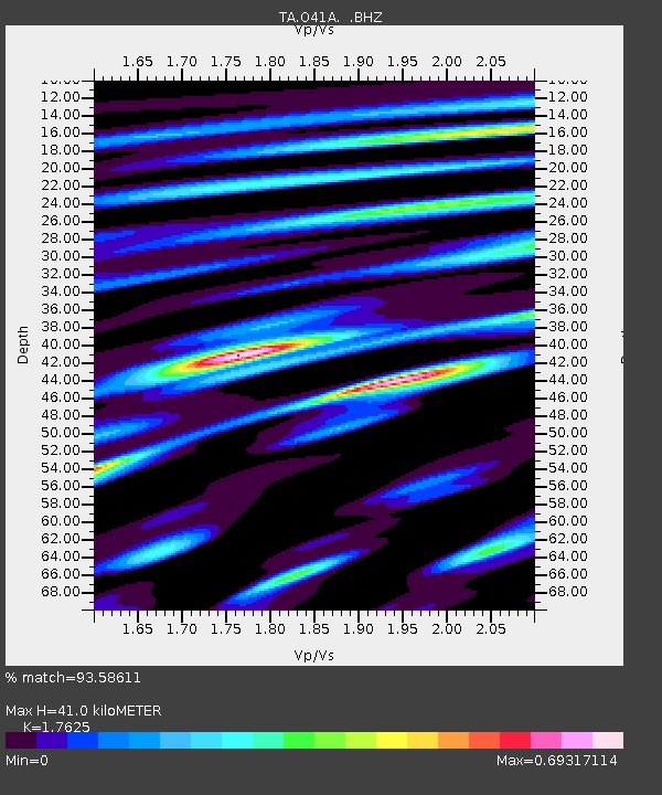
| Estimated Moho Depth: |
41.0 km |
| Estimated Crust Vp/Vs: |
1.76 |
| Assumed Crust Vp: |
6.498 km/s |
| Estimated Crust Vs: |
3.687 km/s |
| Estimated Crust Poisson's Ratio: |
0.26 |
|
| Radial Match: |
93.58611 % |
| Radial Bump: |
336 |
| Transverse Match: |
68.8217 % |
| Transverse Bump: |
400 |
| SOD ConfigId: |
462790 |
| Insert Time: |
2013-02-12 18:07:04.872 +0000 |
| GWidth: |
2.5 |
| Max Bumps: |
400 |
| Tol: |
0.001 |
|

Signal To Noise
| Channel | StoN | STA | LTA |
| TA:O41A: :BHZ:20120624T03:25:08.124971Z | 18.843412 | 8.6382835E-7 | 4.584246E-8 |
| TA:O41A: :BHN:20120624T03:25:08.124971Z | 4.008997 | 3.387233E-7 | 8.449078E-8 |
| TA:O41A: :BHE:20120624T03:25:08.124971Z | 3.3075857 | 2.3172042E-7 | 7.005727E-8 |
| Arrivals |
| Ps | 5.0 SECOND |
| PpPs | 17 SECOND |
| PsPs/PpSs | 22 SECOND |


