You are here: Home > Network List > G - GEOSCOPE Stations List
> Station SSB Saint Sauveur Badole, France > Earthquake Result Viewer
SSB Saint Sauveur Badole, France - Earthquake Result Viewer
| Earthquake location: |
Northern Colombia |
| Earthquake latitude/longitude: |
7.1/-76.9 |
| Earthquake time(UTC): |
1992/10/18 (292) 15:11:59 GMT |
| Earthquake Depth: |
10 km |
| Earthquake Magnitude: |
6.6 MB, 7.3 MS, 7.4 UNKNOWN |
| Earthquake Catalog/Contributor: |
WHDF/NEIC |
|
| Network: |
G GEOSCOPE |
| Station: |
SSB Saint Sauveur Badole, France |
| Lat/Lon: |
45.28 N/4.54 E |
| Elevation: |
700 m |
|
| Distance: |
79.0 deg |
| Az: |
45.344 deg |
| Baz: |
268.963 deg |
| Ray Param: |
0.049294274 |
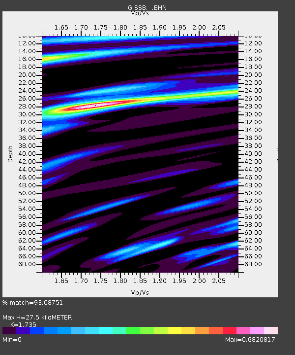
| Estimated Moho Depth: |
27.5 km |
| Estimated Crust Vp/Vs: |
1.74 |
| Assumed Crust Vp: |
6.1 km/s |
| Estimated Crust Vs: |
3.516 km/s |
| Estimated Crust Poisson's Ratio: |
0.25 |
|
| Radial Match: |
93.08751 % |
| Radial Bump: |
222 |
| Transverse Match: |
81.44722 % |
| Transverse Bump: |
400 |
| SOD ConfigId: |
16938 |
| Insert Time: |
2010-02-27 00:07:26.738 +0000 |
| GWidth: |
2.5 |
| Max Bumps: |
400 |
| Tol: |
0.001 |
|
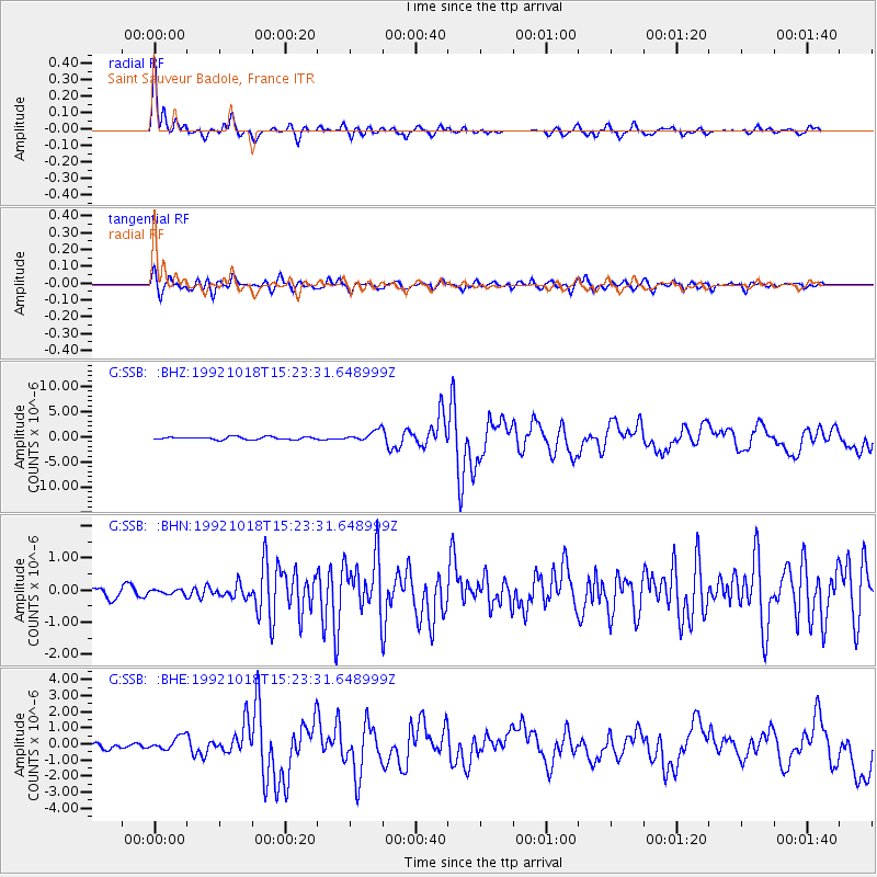
Signal To Noise
| Channel | StoN | STA | LTA |
| G:SSB: :BHN:19921018T15:23:31.648999Z | 0.46314594 | 7.6145156E-8 | 1.6440856E-7 |
| G:SSB: :BHE:19921018T15:23:31.648999Z | 2.516785 | 4.3433238E-7 | 1.7257429E-7 |
| G:SSB: :BHZ:19921018T15:23:31.648999Z | 4.040085 | 1.0597659E-6 | 2.623128E-7 |
| Arrivals |
| Ps | 3.4 SECOND |
| PpPs | 12 SECOND |
| PsPs/PpSs | 15 SECOND |


