You are here: Home > Network List > KN - Kyrgyz Seismic Telemetry Network Stations List
> Station TKM2 - > Earthquake Result Viewer
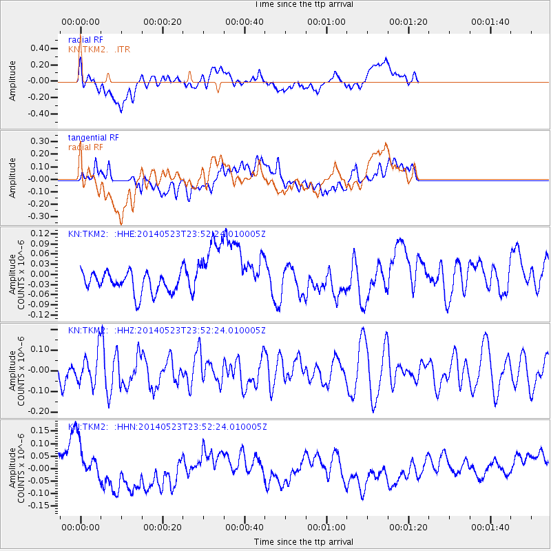
TKM2 - - Earthquake Result Viewer
*The percent match for this event was below the threshold and hence no stack was calculated.
| Earthquake location: |
Northern Mid-Atlantic Ridge |
| Earthquake latitude/longitude: |
45.0/-27.8 |
| Earthquake time(UTC): |
2014/05/23 (143) 23:41:49 GMT |
| Earthquake Depth: |
10 km |
| Earthquake Magnitude: |
5.5 MWC, 5.5 MWC |
| Earthquake Catalog/Contributor: |
NEIC PDE/NEIC COMCAT |
|
| Network: |
KN Kyrgyz Seismic Telemetry Network |
| Station: |
TKM2 - |
| Lat/Lon: |
42.92 N/75.60 E |
| Elevation: |
2020 m |
|
| Distance: |
69.0 deg |
| Az: |
49.912 deg |
| Baz: |
312.404 deg |
| Ray Param: |
$rayparam |
*The percent match for this event was below the threshold and hence was not used in the summary stack. |
|
| Radial Match: |
35.93639 % |
| Radial Bump: |
400 |
| Transverse Match: |
29.268974 % |
| Transverse Bump: |
400 |
| SOD ConfigId: |
3390531 |
| Insert Time: |
2019-04-12 00:29:00.035 +0000 |
| GWidth: |
2.5 |
| Max Bumps: |
400 |
| Tol: |
0.001 |
|
Signal To Noise
| Channel | StoN | STA | LTA |
| KN:TKM2: :HHZ:20140523T23:52:24.010005Z | 1.1413116 | 8.052985E-8 | 7.055904E-8 |
| KN:TKM2: :HHN:20140523T23:52:24.010005Z | 1.5319268 | 6.344427E-8 | 4.1414687E-8 |
| KN:TKM2: :HHE:20140523T23:52:24.010005Z | 3.309344 | 9.80782E-8 | 2.963675E-8 |
| Arrivals |
| Ps | |
| PpPs | |
| PsPs/PpSs | |


