You are here: Home > Network List > CI - Caltech Regional Seismic Network Stations List
> Station MPM Manuel Prospect Mine, California, USA > Earthquake Result Viewer
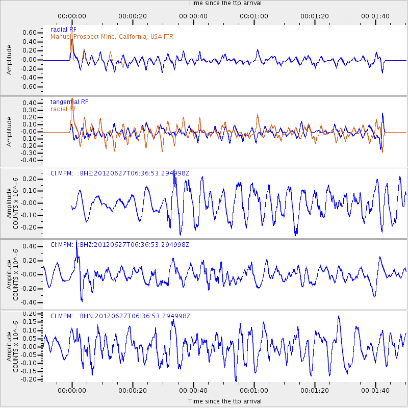
MPM Manuel Prospect Mine, California, USA - Earthquake Result Viewer
*The percent match for this event was below the threshold and hence no stack was calculated.
| Earthquake location: |
El Salvador |
| Earthquake latitude/longitude: |
13.8/-90.0 |
| Earthquake time(UTC): |
2012/06/27 (179) 06:30:59 GMT |
| Earthquake Depth: |
133 km |
| Earthquake Magnitude: |
5.7 MW, 5.4 MB, 5.7 MW |
| Earthquake Catalog/Contributor: |
WHDF/NEIC |
|
| Network: |
CI Caltech Regional Seismic Network |
| Station: |
MPM Manuel Prospect Mine, California, USA |
| Lat/Lon: |
36.06 N/117.49 W |
| Elevation: |
185 m |
|
| Distance: |
33.1 deg |
| Az: |
316.784 deg |
| Baz: |
124.828 deg |
| Ray Param: |
$rayparam |
*The percent match for this event was below the threshold and hence was not used in the summary stack. |
|
| Radial Match: |
63.682083 % |
| Radial Bump: |
400 |
| Transverse Match: |
52.23053 % |
| Transverse Bump: |
400 |
| SOD ConfigId: |
463687 |
| Insert Time: |
2013-02-20 16:19:33.818 +0000 |
| GWidth: |
2.5 |
| Max Bumps: |
400 |
| Tol: |
0.001 |
|
Signal To Noise
| Channel | StoN | STA | LTA |
| CI:MPM: :BHZ:20120627T06:36:53.294998Z | 3.1251407 | 2.0165078E-7 | 6.452534E-8 |
| CI:MPM: :BHN:20120627T06:36:53.294998Z | 1.6355453 | 7.129415E-8 | 4.3590447E-8 |
| CI:MPM: :BHE:20120627T06:36:53.294998Z | 1.8290182 | 1.1681413E-7 | 6.386712E-8 |
| Arrivals |
| Ps | |
| PpPs | |
| PsPs/PpSs | |


