You are here: Home > Network List > CI - Caltech Regional Seismic Network Stations List
> Station SMM Simmler, CA, USA > Earthquake Result Viewer
SMM Simmler, CA, USA - Earthquake Result Viewer
*The percent match for this event was below the threshold and hence no stack was calculated.
| Earthquake location: |
El Salvador |
| Earthquake latitude/longitude: |
13.8/-90.0 |
| Earthquake time(UTC): |
2012/06/27 (179) 06:30:59 GMT |
| Earthquake Depth: |
133 km |
| Earthquake Magnitude: |
5.7 MW, 5.4 MB, 5.7 MW |
| Earthquake Catalog/Contributor: |
WHDF/NEIC |
|
| Network: |
CI Caltech Regional Seismic Network |
| Station: |
SMM Simmler, CA, USA |
| Lat/Lon: |
35.31 N/120.00 W |
| Elevation: |
599 m |
|
| Distance: |
34.5 deg |
| Az: |
313.675 deg |
| Baz: |
120.789 deg |
| Ray Param: |
$rayparam |
*The percent match for this event was below the threshold and hence was not used in the summary stack. |
|
| Radial Match: |
53.82651 % |
| Radial Bump: |
374 |
| Transverse Match: |
69.62046 % |
| Transverse Bump: |
400 |
| SOD ConfigId: |
463687 |
| Insert Time: |
2013-02-20 16:19:59.785 +0000 |
| GWidth: |
2.5 |
| Max Bumps: |
400 |
| Tol: |
0.001 |
|
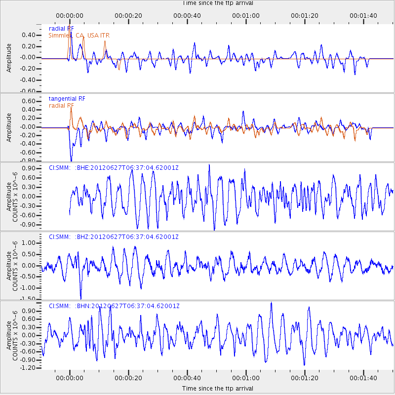
Signal To Noise
| Channel | StoN | STA | LTA |
| CI:SMM: :BHZ:20120627T06:37:04.62001Z | 2.6047118 | 4.998224E-7 | 1.9189164E-7 |
| CI:SMM: :BHN:20120627T06:37:04.62001Z | 0.8630379 | 3.4065025E-7 | 3.9471067E-7 |
| CI:SMM: :BHE:20120627T06:37:04.62001Z | 1.0232763 | 4.1404095E-7 | 4.0462282E-7 |
| Arrivals |
| Ps | |
| PpPs | |
| PsPs/PpSs | |


