You are here: Home > Network List > CI - Caltech Regional Seismic Network Stations List
> Station TUQ Turquiose Mountain, Baker, CA, USA > Earthquake Result Viewer
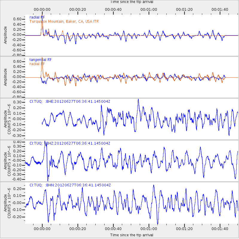
TUQ Turquiose Mountain, Baker, CA, USA - Earthquake Result Viewer
*The percent match for this event was below the threshold and hence no stack was calculated.
| Earthquake location: |
El Salvador |
| Earthquake latitude/longitude: |
13.8/-90.0 |
| Earthquake time(UTC): |
2012/06/27 (179) 06:30:59 GMT |
| Earthquake Depth: |
133 km |
| Earthquake Magnitude: |
5.7 MW, 5.4 MB, 5.7 MW |
| Earthquake Catalog/Contributor: |
WHDF/NEIC |
|
| Network: |
CI Caltech Regional Seismic Network |
| Station: |
TUQ Turquiose Mountain, Baker, CA, USA |
| Lat/Lon: |
35.44 N/115.92 W |
| Elevation: |
1350 m |
|
| Distance: |
31.8 deg |
| Az: |
317.218 deg |
| Baz: |
126.105 deg |
| Ray Param: |
$rayparam |
*The percent match for this event was below the threshold and hence was not used in the summary stack. |
|
| Radial Match: |
71.2196 % |
| Radial Bump: |
400 |
| Transverse Match: |
58.541885 % |
| Transverse Bump: |
376 |
| SOD ConfigId: |
463687 |
| Insert Time: |
2013-02-20 16:20:53.530 +0000 |
| GWidth: |
2.5 |
| Max Bumps: |
400 |
| Tol: |
0.001 |
|
Signal To Noise
| Channel | StoN | STA | LTA |
| CI:TUQ: :BHZ:20120627T06:36:41.145004Z | 2.7418265 | 2.3608698E-7 | 8.610573E-8 |
| CI:TUQ: :BHN:20120627T06:36:41.145004Z | 1.8289609 | 1.2472854E-7 | 6.819639E-8 |
| CI:TUQ: :BHE:20120627T06:36:41.145004Z | 1.852931 | 1.4354686E-7 | 7.7470155E-8 |
| Arrivals |
| Ps | |
| PpPs | |
| PsPs/PpSs | |


