You are here: Home > Network List > G - GEOSCOPE Stations List
> Station SSB Saint Sauveur Badole, France > Earthquake Result Viewer
SSB Saint Sauveur Badole, France - Earthquake Result Viewer
| Earthquake location: |
Near West Coast Of Honshu, Japan |
| Earthquake latitude/longitude: |
37.6/137.3 |
| Earthquake time(UTC): |
1993/02/07 (038) 13:27:43 GMT |
| Earthquake Depth: |
24 km |
| Earthquake Magnitude: |
6.3 MB, 6.1 MS |
| Earthquake Catalog/Contributor: |
WHDF/NEIC |
|
| Network: |
G GEOSCOPE |
| Station: |
SSB Saint Sauveur Badole, France |
| Lat/Lon: |
45.28 N/4.54 E |
| Elevation: |
700 m |
|
| Distance: |
87.1 deg |
| Az: |
328.71 deg |
| Baz: |
35.746 deg |
| Ray Param: |
0.04351804 |
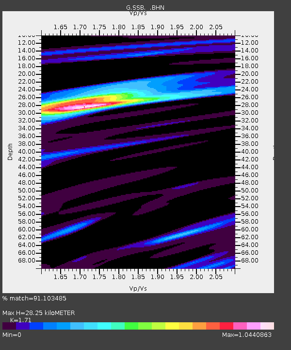
| Estimated Moho Depth: |
28.25 km |
| Estimated Crust Vp/Vs: |
1.71 |
| Assumed Crust Vp: |
6.1 km/s |
| Estimated Crust Vs: |
3.567 km/s |
| Estimated Crust Poisson's Ratio: |
0.24 |
|
| Radial Match: |
91.103485 % |
| Radial Bump: |
400 |
| Transverse Match: |
46.62373 % |
| Transverse Bump: |
400 |
| SOD ConfigId: |
16938 |
| Insert Time: |
2010-02-27 00:07:38.514 +0000 |
| GWidth: |
2.5 |
| Max Bumps: |
400 |
| Tol: |
0.001 |
|

Signal To Noise
| Channel | StoN | STA | LTA |
| G:SSB: :BHN:19930207T13:39:56.300024Z | 2.2704604 | 3.6956288E-7 | 1.6277002E-7 |
| G:SSB: :BHE:19930207T13:39:56.300024Z | 3.747313 | 4.429082E-7 | 1.1819354E-7 |
| G:SSB: :BHZ:19930207T13:39:56.300024Z | 5.9062066 | 1.3001969E-6 | 2.2014078E-7 |
| Arrivals |
| Ps | 3.4 SECOND |
| PpPs | 12 SECOND |
| PsPs/PpSs | 16 SECOND |


