You are here: Home > Network List > TA - USArray Transportable Network (new EarthScope stations) Stations List
> Station L04D Klamath Falls, OR, USA > Earthquake Result Viewer
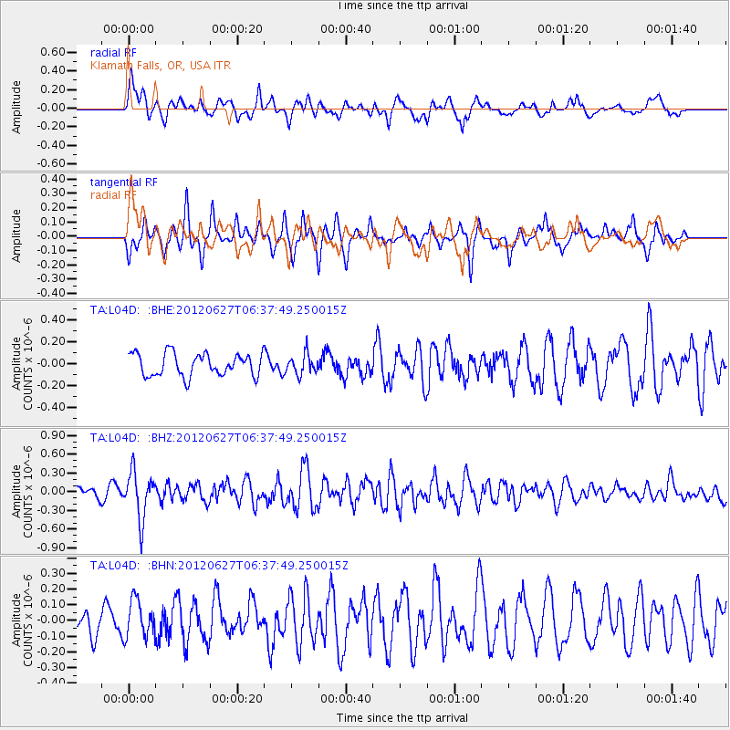
L04D Klamath Falls, OR, USA - Earthquake Result Viewer
*The percent match for this event was below the threshold and hence no stack was calculated.
| Earthquake location: |
El Salvador |
| Earthquake latitude/longitude: |
13.8/-90.0 |
| Earthquake time(UTC): |
2012/06/27 (179) 06:30:59 GMT |
| Earthquake Depth: |
133 km |
| Earthquake Magnitude: |
5.7 MW, 5.4 MB, 5.7 MW |
| Earthquake Catalog/Contributor: |
WHDF/NEIC |
|
| Network: |
TA USArray Transportable Network (new EarthScope stations) |
| Station: |
L04D Klamath Falls, OR, USA |
| Lat/Lon: |
42.22 N/122.30 W |
| Elevation: |
1437 m |
|
| Distance: |
39.8 deg |
| Az: |
321.592 deg |
| Baz: |
125.67 deg |
| Ray Param: |
$rayparam |
*The percent match for this event was below the threshold and hence was not used in the summary stack. |
|
| Radial Match: |
73.54902 % |
| Radial Bump: |
400 |
| Transverse Match: |
73.02897 % |
| Transverse Bump: |
327 |
| SOD ConfigId: |
463687 |
| Insert Time: |
2013-02-20 16:26:33.846 +0000 |
| GWidth: |
2.5 |
| Max Bumps: |
400 |
| Tol: |
0.001 |
|
Signal To Noise
| Channel | StoN | STA | LTA |
| TA:L04D: :BHZ:20120627T06:37:49.250015Z | 3.614747 | 3.779832E-7 | 1.0456699E-7 |
| TA:L04D: :BHN:20120627T06:37:49.250015Z | 1.2763076 | 1.18518166E-7 | 9.286018E-8 |
| TA:L04D: :BHE:20120627T06:37:49.250015Z | 0.890929 | 9.101071E-8 | 1.021526E-7 |
| Arrivals |
| Ps | |
| PpPs | |
| PsPs/PpSs | |


