You are here: Home > Network List > TA - USArray Transportable Network (new EarthScope stations) Stations List
> Station H37A Dierke Farm, Cannon Falls, MN, USA > Earthquake Result Viewer
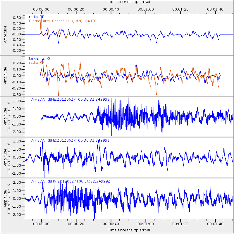
H37A Dierke Farm, Cannon Falls, MN, USA - Earthquake Result Viewer
*The percent match for this event was below the threshold and hence no stack was calculated.
| Earthquake location: |
El Salvador |
| Earthquake latitude/longitude: |
13.8/-90.0 |
| Earthquake time(UTC): |
2012/06/27 (179) 06:30:59 GMT |
| Earthquake Depth: |
133 km |
| Earthquake Magnitude: |
5.7 MW, 5.4 MB, 5.7 MW |
| Earthquake Catalog/Contributor: |
WHDF/NEIC |
|
| Network: |
TA USArray Transportable Network (new EarthScope stations) |
| Station: |
H37A Dierke Farm, Cannon Falls, MN, USA |
| Lat/Lon: |
44.58 N/92.92 W |
| Elevation: |
321 m |
|
| Distance: |
30.7 deg |
| Az: |
355.873 deg |
| Baz: |
174.387 deg |
| Ray Param: |
$rayparam |
*The percent match for this event was below the threshold and hence was not used in the summary stack. |
|
| Radial Match: |
58.612236 % |
| Radial Bump: |
400 |
| Transverse Match: |
57.84879 % |
| Transverse Bump: |
400 |
| SOD ConfigId: |
463687 |
| Insert Time: |
2013-02-20 16:29:08.981 +0000 |
| GWidth: |
2.5 |
| Max Bumps: |
400 |
| Tol: |
0.001 |
|
Signal To Noise
| Channel | StoN | STA | LTA |
| TA:H37A: :BHZ:20120627T06:36:32.34999Z | 2.3886607 | 8.6095974E-7 | 3.604362E-7 |
| TA:H37A: :BHN:20120627T06:36:32.34999Z | 2.0919895 | 8.51297E-7 | 4.0693178E-7 |
| TA:H37A: :BHE:20120627T06:36:32.34999Z | 2.5329869 | 5.930703E-7 | 2.341387E-7 |
| Arrivals |
| Ps | |
| PpPs | |
| PsPs/PpSs | |


