You are here: Home > Network List > TA - USArray Transportable Network (new EarthScope stations) Stations List
> Station E36A McGregor, MN, USA > Earthquake Result Viewer
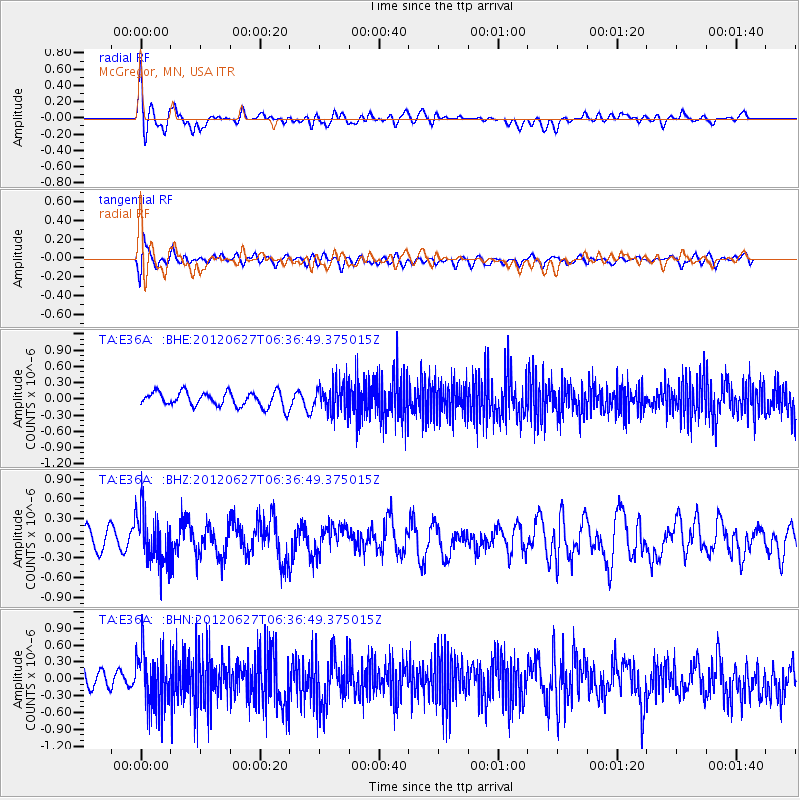
E36A McGregor, MN, USA - Earthquake Result Viewer
*The percent match for this event was below the threshold and hence no stack was calculated.
| Earthquake location: |
El Salvador |
| Earthquake latitude/longitude: |
13.8/-90.0 |
| Earthquake time(UTC): |
2012/06/27 (179) 06:30:59 GMT |
| Earthquake Depth: |
133 km |
| Earthquake Magnitude: |
5.7 MW, 5.4 MB, 5.7 MW |
| Earthquake Catalog/Contributor: |
WHDF/NEIC |
|
| Network: |
TA USArray Transportable Network (new EarthScope stations) |
| Station: |
E36A McGregor, MN, USA |
| Lat/Lon: |
46.52 N/93.26 W |
| Elevation: |
393 m |
|
| Distance: |
32.7 deg |
| Az: |
355.795 deg |
| Baz: |
174.079 deg |
| Ray Param: |
$rayparam |
*The percent match for this event was below the threshold and hence was not used in the summary stack. |
|
| Radial Match: |
57.298298 % |
| Radial Bump: |
400 |
| Transverse Match: |
44.23771 % |
| Transverse Bump: |
400 |
| SOD ConfigId: |
463687 |
| Insert Time: |
2013-02-20 16:29:43.244 +0000 |
| GWidth: |
2.5 |
| Max Bumps: |
400 |
| Tol: |
0.001 |
|
Signal To Noise
| Channel | StoN | STA | LTA |
| TA:E36A: :BHZ:20120627T06:36:49.375015Z | 2.6074734 | 3.916024E-7 | 1.5018463E-7 |
| TA:E36A: :BHN:20120627T06:36:49.375015Z | 3.438889 | 5.023485E-7 | 1.4607872E-7 |
| TA:E36A: :BHE:20120627T06:36:49.375015Z | 1.8330214 | 2.5067695E-7 | 1.3675614E-7 |
| Arrivals |
| Ps | |
| PpPs | |
| PsPs/PpSs | |


