You are here: Home > Network List > TA - USArray Transportable Network (new EarthScope stations) Stations List
> Station F39A Loretta, WI, USA > Earthquake Result Viewer
F39A Loretta, WI, USA - Earthquake Result Viewer
*The percent match for this event was below the threshold and hence no stack was calculated.
| Earthquake location: |
El Salvador |
| Earthquake latitude/longitude: |
13.8/-90.0 |
| Earthquake time(UTC): |
2012/06/27 (179) 06:30:59 GMT |
| Earthquake Depth: |
133 km |
| Earthquake Magnitude: |
5.7 MW, 5.4 MB, 5.7 MW |
| Earthquake Catalog/Contributor: |
WHDF/NEIC |
|
| Network: |
TA USArray Transportable Network (new EarthScope stations) |
| Station: |
F39A Loretta, WI, USA |
| Lat/Lon: |
45.92 N/90.92 W |
| Elevation: |
440 m |
|
| Distance: |
32.0 deg |
| Az: |
358.745 deg |
| Baz: |
178.254 deg |
| Ray Param: |
$rayparam |
*The percent match for this event was below the threshold and hence was not used in the summary stack. |
|
| Radial Match: |
65.49986 % |
| Radial Bump: |
400 |
| Transverse Match: |
61.077305 % |
| Transverse Bump: |
400 |
| SOD ConfigId: |
463687 |
| Insert Time: |
2013-02-20 16:31:24.770 +0000 |
| GWidth: |
2.5 |
| Max Bumps: |
400 |
| Tol: |
0.001 |
|
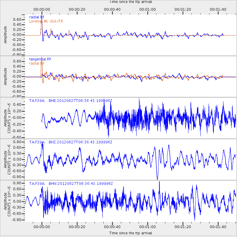
Signal To Noise
| Channel | StoN | STA | LTA |
| TA:F39A: :BHZ:20120627T06:36:43.199996Z | 1.9416671 | 4.231818E-7 | 2.1794767E-7 |
| TA:F39A: :BHN:20120627T06:36:43.199996Z | 2.294294 | 3.8186306E-7 | 1.6644033E-7 |
| TA:F39A: :BHE:20120627T06:36:43.199996Z | 1.0367512 | 1.3065595E-7 | 1.260244E-7 |
| Arrivals |
| Ps | |
| PpPs | |
| PsPs/PpSs | |


