You are here: Home > Network List > TA - USArray Transportable Network (new EarthScope stations) Stations List
> Station D41A Chassel, MI, USA > Earthquake Result Viewer
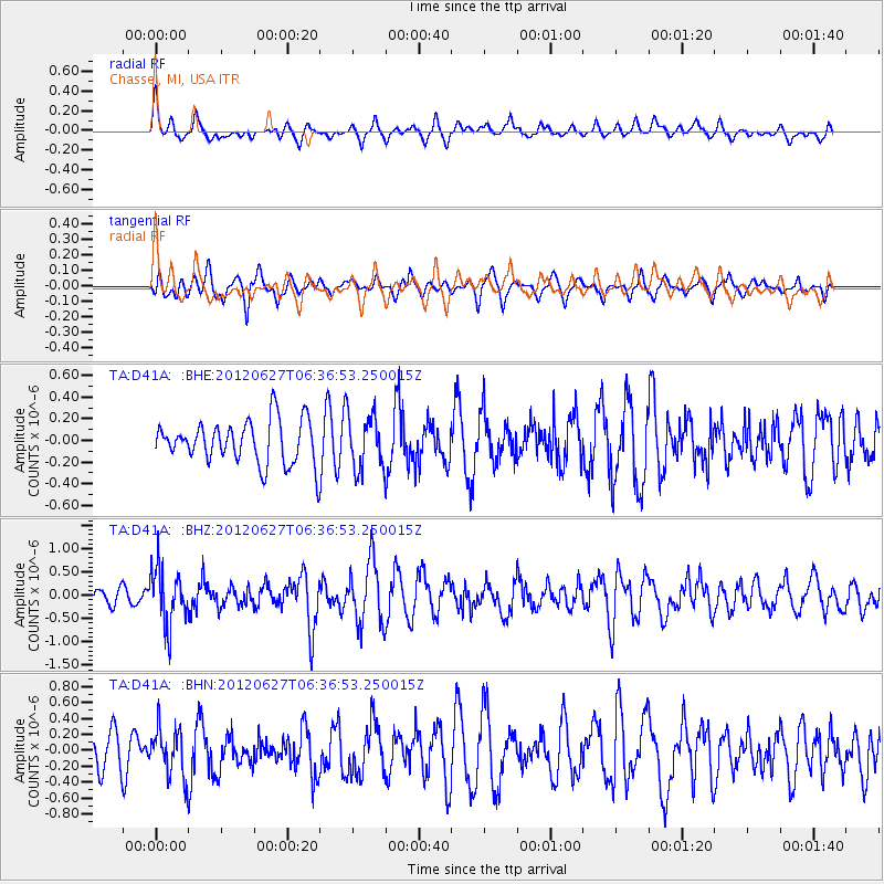
D41A Chassel, MI, USA - Earthquake Result Viewer
*The percent match for this event was below the threshold and hence no stack was calculated.
| Earthquake location: |
El Salvador |
| Earthquake latitude/longitude: |
13.8/-90.0 |
| Earthquake time(UTC): |
2012/06/27 (179) 06:30:59 GMT |
| Earthquake Depth: |
133 km |
| Earthquake Magnitude: |
5.7 MW, 5.4 MB, 5.7 MW |
| Earthquake Catalog/Contributor: |
WHDF/NEIC |
|
| Network: |
TA USArray Transportable Network (new EarthScope stations) |
| Station: |
D41A Chassel, MI, USA |
| Lat/Lon: |
47.06 N/88.57 W |
| Elevation: |
271 m |
|
| Distance: |
33.1 deg |
| Az: |
1.752 deg |
| Baz: |
182.49 deg |
| Ray Param: |
$rayparam |
*The percent match for this event was below the threshold and hence was not used in the summary stack. |
|
| Radial Match: |
54.194897 % |
| Radial Bump: |
357 |
| Transverse Match: |
56.39298 % |
| Transverse Bump: |
351 |
| SOD ConfigId: |
463687 |
| Insert Time: |
2013-02-20 16:31:36.986 +0000 |
| GWidth: |
2.5 |
| Max Bumps: |
400 |
| Tol: |
0.001 |
|
Signal To Noise
| Channel | StoN | STA | LTA |
| TA:D41A: :BHZ:20120627T06:36:53.250015Z | 4.9457994 | 6.059056E-7 | 1.2250914E-7 |
| TA:D41A: :BHN:20120627T06:36:53.250015Z | 1.647269 | 2.9979762E-7 | 1.8199677E-7 |
| TA:D41A: :BHE:20120627T06:36:53.250015Z | 1.2479447 | 2.473222E-7 | 1.981836E-7 |
| Arrivals |
| Ps | |
| PpPs | |
| PsPs/PpSs | |


