You are here: Home > Network List > TA - USArray Transportable Network (new EarthScope stations) Stations List
> Station G43A Wallace, MI, USA > Earthquake Result Viewer
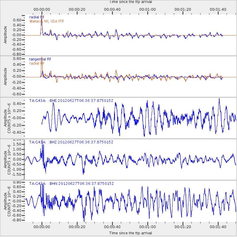
G43A Wallace, MI, USA - Earthquake Result Viewer
*The percent match for this event was below the threshold and hence no stack was calculated.
| Earthquake location: |
El Salvador |
| Earthquake latitude/longitude: |
13.8/-90.0 |
| Earthquake time(UTC): |
2012/06/27 (179) 06:30:59 GMT |
| Earthquake Depth: |
133 km |
| Earthquake Magnitude: |
5.7 MW, 5.4 MB, 5.7 MW |
| Earthquake Catalog/Contributor: |
WHDF/NEIC |
|
| Network: |
TA USArray Transportable Network (new EarthScope stations) |
| Station: |
G43A Wallace, MI, USA |
| Lat/Lon: |
45.26 N/87.69 W |
| Elevation: |
213 m |
|
| Distance: |
31.4 deg |
| Az: |
3.095 deg |
| Baz: |
184.258 deg |
| Ray Param: |
$rayparam |
*The percent match for this event was below the threshold and hence was not used in the summary stack. |
|
| Radial Match: |
69.03509 % |
| Radial Bump: |
359 |
| Transverse Match: |
48.684643 % |
| Transverse Bump: |
400 |
| SOD ConfigId: |
463687 |
| Insert Time: |
2013-02-20 16:31:40.267 +0000 |
| GWidth: |
2.5 |
| Max Bumps: |
400 |
| Tol: |
0.001 |
|
Signal To Noise
| Channel | StoN | STA | LTA |
| TA:G43A: :BHZ:20120627T06:36:37.875015Z | 3.0758405 | 6.1761693E-7 | 2.0079615E-7 |
| TA:G43A: :BHN:20120627T06:36:37.875015Z | 2.270012 | 2.9234826E-7 | 1.2878711E-7 |
| TA:G43A: :BHE:20120627T06:36:37.875015Z | 1.0287024 | 1.496949E-7 | 1.4551819E-7 |
| Arrivals |
| Ps | |
| PpPs | |
| PsPs/PpSs | |


