You are here: Home > Network List > TA - USArray Transportable Network (new EarthScope stations) Stations List
> Station I42A Draeger Farm, Ripon, WI, USA > Earthquake Result Viewer
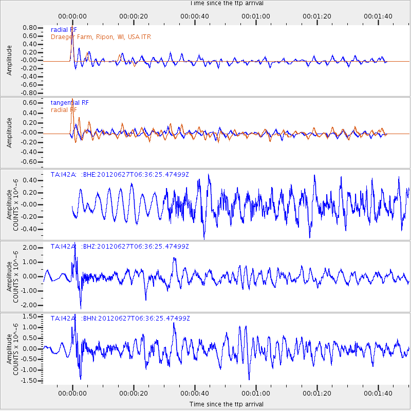
I42A Draeger Farm, Ripon, WI, USA - Earthquake Result Viewer
| Earthquake location: |
El Salvador |
| Earthquake latitude/longitude: |
13.8/-90.0 |
| Earthquake time(UTC): |
2012/06/27 (179) 06:30:59 GMT |
| Earthquake Depth: |
133 km |
| Earthquake Magnitude: |
5.7 MW, 5.4 MB, 5.7 MW |
| Earthquake Catalog/Contributor: |
WHDF/NEIC |
|
| Network: |
TA USArray Transportable Network (new EarthScope stations) |
| Station: |
I42A Draeger Farm, Ripon, WI, USA |
| Lat/Lon: |
43.89 N/88.91 W |
| Elevation: |
298 m |
|
| Distance: |
30.0 deg |
| Az: |
1.525 deg |
| Baz: |
182.049 deg |
| Ray Param: |
0.07922411 |
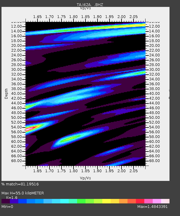
| Estimated Moho Depth: |
55.0 km |
| Estimated Crust Vp/Vs: |
1.60 |
| Assumed Crust Vp: |
6.571 km/s |
| Estimated Crust Vs: |
4.107 km/s |
| Estimated Crust Poisson's Ratio: |
0.18 |
|
| Radial Match: |
81.19516 % |
| Radial Bump: |
400 |
| Transverse Match: |
74.37646 % |
| Transverse Bump: |
400 |
| SOD ConfigId: |
463687 |
| Insert Time: |
2013-02-20 16:32:16.042 +0000 |
| GWidth: |
2.5 |
| Max Bumps: |
400 |
| Tol: |
0.001 |
|
Signal To Noise
| Channel | StoN | STA | LTA |
| TA:I42A: :BHZ:20120627T06:36:25.47499Z | 2.667291 | 8.504889E-7 | 3.188587E-7 |
| TA:I42A: :BHN:20120627T06:36:25.47499Z | 3.5382988 | 6.421845E-7 | 1.8149527E-7 |
| TA:I42A: :BHE:20120627T06:36:25.47499Z | 0.82570976 | 1.3866725E-7 | 1.6793702E-7 |
| Arrivals |
| Ps | 5.5 SECOND |
| PpPs | 20 SECOND |
| PsPs/PpSs | 25 SECOND |


