You are here: Home > Network List > UW - Pacific Northwest Regional Seismic Network Stations List
> Station TAKO Tahkenitch, OR CREST BB SMO > Earthquake Result Viewer
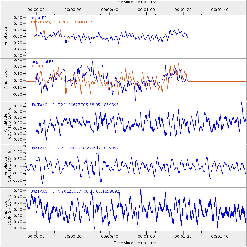
TAKO Tahkenitch, OR CREST BB SMO - Earthquake Result Viewer
*The percent match for this event was below the threshold and hence no stack was calculated.
| Earthquake location: |
El Salvador |
| Earthquake latitude/longitude: |
13.8/-90.0 |
| Earthquake time(UTC): |
2012/06/27 (179) 06:30:59 GMT |
| Earthquake Depth: |
133 km |
| Earthquake Magnitude: |
5.7 MW, 5.4 MB, 5.7 MW |
| Earthquake Catalog/Contributor: |
WHDF/NEIC |
|
| Network: |
UW Pacific Northwest Regional Seismic Network |
| Station: |
TAKO Tahkenitch, OR CREST BB SMO |
| Lat/Lon: |
43.74 N/124.08 W |
| Elevation: |
46 m |
|
| Distance: |
41.7 deg |
| Az: |
322.34 deg |
| Baz: |
125.03 deg |
| Ray Param: |
$rayparam |
*The percent match for this event was below the threshold and hence was not used in the summary stack. |
|
| Radial Match: |
56.770557 % |
| Radial Bump: |
400 |
| Transverse Match: |
62.42289 % |
| Transverse Bump: |
400 |
| SOD ConfigId: |
463687 |
| Insert Time: |
2013-02-20 16:33:30.030 +0000 |
| GWidth: |
2.5 |
| Max Bumps: |
400 |
| Tol: |
0.001 |
|
Signal To Noise
| Channel | StoN | STA | LTA |
| UW:TAKO: :BHZ:20120627T06:38:05.185989Z | 2.2983325 | 5.6988847E-7 | 2.4795736E-7 |
| UW:TAKO: :BHN:20120627T06:38:05.185989Z | 1.5655692 | 3.0313976E-7 | 1.936291E-7 |
| UW:TAKO: :BHE:20120627T06:38:05.185989Z | 1.1111183 | 1.9375267E-7 | 1.7437627E-7 |
| Arrivals |
| Ps | |
| PpPs | |
| PsPs/PpSs | |


