You are here: Home > Network List > UW - Pacific Northwest Regional Seismic Network Stations List
> Station LEBA Lebam, WA, USA > Earthquake Result Viewer
LEBA Lebam, WA, USA - Earthquake Result Viewer
*The percent match for this event was below the threshold and hence no stack was calculated.
| Earthquake location: |
El Salvador |
| Earthquake latitude/longitude: |
13.8/-90.0 |
| Earthquake time(UTC): |
2012/06/27 (179) 06:30:59 GMT |
| Earthquake Depth: |
133 km |
| Earthquake Magnitude: |
5.7 MW, 5.4 MB, 5.7 MW |
| Earthquake Catalog/Contributor: |
WHDF/NEIC |
|
| Network: |
UW Pacific Northwest Regional Seismic Network |
| Station: |
LEBA Lebam, WA, USA |
| Lat/Lon: |
46.55 N/123.56 W |
| Elevation: |
73 m |
|
| Distance: |
43.1 deg |
| Az: |
326.004 deg |
| Baz: |
128.103 deg |
| Ray Param: |
$rayparam |
*The percent match for this event was below the threshold and hence was not used in the summary stack. |
|
| Radial Match: |
47.996544 % |
| Radial Bump: |
400 |
| Transverse Match: |
58.81736 % |
| Transverse Bump: |
400 |
| SOD ConfigId: |
463687 |
| Insert Time: |
2013-02-20 16:34:16.247 +0000 |
| GWidth: |
2.5 |
| Max Bumps: |
400 |
| Tol: |
0.001 |
|
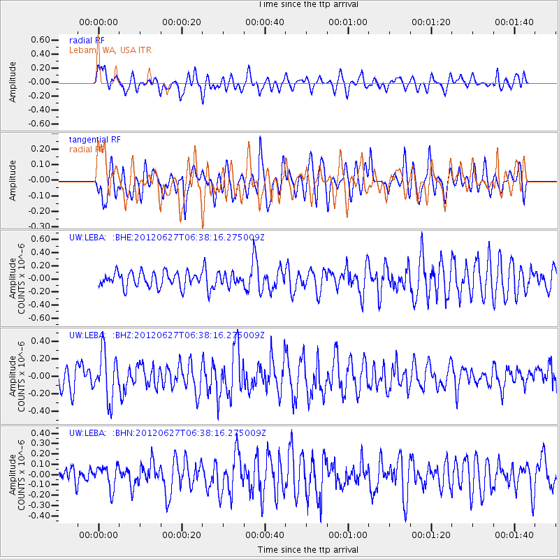
Signal To Noise
| Channel | StoN | STA | LTA |
| UW:LEBA: :BHZ:20120627T06:38:16.275009Z | 2.2370286 | 2.6920605E-7 | 1.203409E-7 |
| UW:LEBA: :BHN:20120627T06:38:16.275009Z | 0.78898996 | 1.136445E-7 | 1.4403795E-7 |
| UW:LEBA: :BHE:20120627T06:38:16.275009Z | 0.73848003 | 8.104453E-8 | 1.0974505E-7 |
| Arrivals |
| Ps | |
| PpPs | |
| PsPs/PpSs | |


