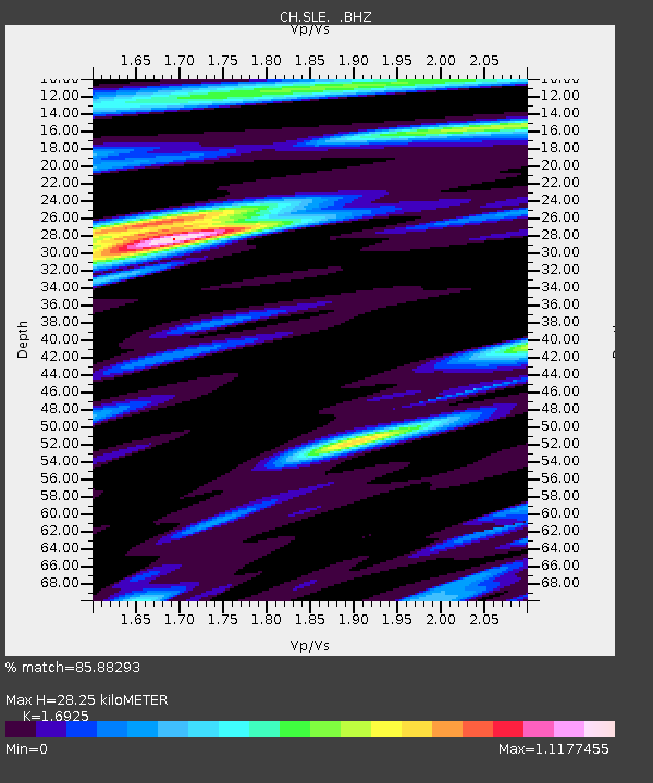
SLE Schleitheim - Earthquake Result Viewer

Earthquake location: South Atlantic Ocean
Earthquake latitude/longitude: -24.7/-9.7
Earthquake time(UTC): 2012/06/29 (181) 15:31:46 GMT
Earthquake Depth: 10 km
Earthquake Magnitude: 6.0 MB, 5.2 MS, 5.8 MW, 5.8 MW
Earthquake Catalog/Contributor: WHDF/NEIC
Network: CH Switzerland Seismological Network
Station: SLE Schleitheim
Lat/Lon: 47.76 N/8.49 E
Elevation: 648 m
Distance: 74.0 deg
Az: 12.632 deg
Baz: 197.141 deg
Ray Param: 0.052626077
Estimated Moho Depth: 28.25 km
Estimated Crust Vp/Vs: 1.69
Assumed Crust Vp: 6.416 km/s
Estimated Crust Vs: 3.791 km/s
Estimated Crust Poisson's Ratio: 0.23
Radial Match: 85.88293 %
Radial Bump: 400
Transverse Match: 72.8306 %
Transverse Bump: 400
SOD ConfigId: 463687
Insert Time: 2013-02-20 16:38:10.417 +0000
GWidth: 2.5
Max Bumps: 400
Tol: 0.001

Signal To Noise

ChannelStoNSTALTA
CH:SLE: :BHZ:20120629T15:42:51.034023Z14.0011691.224357E-68.744677E-8
CH:SLE: :BHN:20120629T15:42:51.042996Z5.5457975.113828E-79.2210875E-8
CH:SLE: :BHE:20120629T15:42:51.034023Z3.18798182.3607289E-77.4050895E-8
Arrivals
Ps3.2 SECOND
PpPs11 SECOND
PsPs/PpSs15 SECOND