You are here: Home > Network List > G - GEOSCOPE Stations List
> Station SSB Saint Sauveur Badole, France > Earthquake Result Viewer
SSB Saint Sauveur Badole, France - Earthquake Result Viewer
| Earthquake location: |
Southern California |
| Earthquake latitude/longitude: |
34.2/-118.5 |
| Earthquake time(UTC): |
1994/01/17 (017) 12:30:55 GMT |
| Earthquake Depth: |
18 km |
| Earthquake Magnitude: |
6.4 MB, 6.8 MS, 6.7 UNKNOWN, 6.7 MW |
| Earthquake Catalog/Contributor: |
WHDF/NEIC |
|
| Network: |
G GEOSCOPE |
| Station: |
SSB Saint Sauveur Badole, France |
| Lat/Lon: |
45.28 N/4.54 E |
| Elevation: |
700 m |
|
| Distance: |
85.6 deg |
| Az: |
36.397 deg |
| Baz: |
315.856 deg |
| Ray Param: |
0.0446468 |
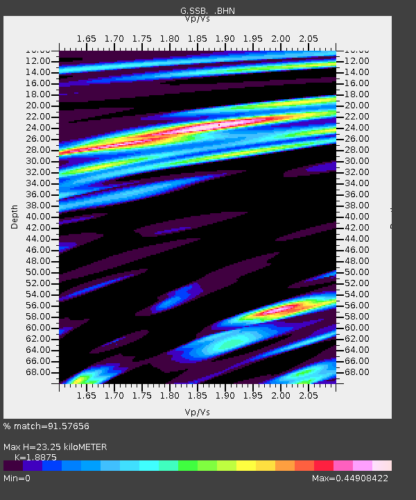
| Estimated Moho Depth: |
23.25 km |
| Estimated Crust Vp/Vs: |
1.89 |
| Assumed Crust Vp: |
6.1 km/s |
| Estimated Crust Vs: |
3.232 km/s |
| Estimated Crust Poisson's Ratio: |
0.30 |
|
| Radial Match: |
91.57656 % |
| Radial Bump: |
400 |
| Transverse Match: |
76.16851 % |
| Transverse Bump: |
400 |
| SOD ConfigId: |
16938 |
| Insert Time: |
2010-02-27 00:08:20.274 +0000 |
| GWidth: |
2.5 |
| Max Bumps: |
400 |
| Tol: |
0.001 |
|
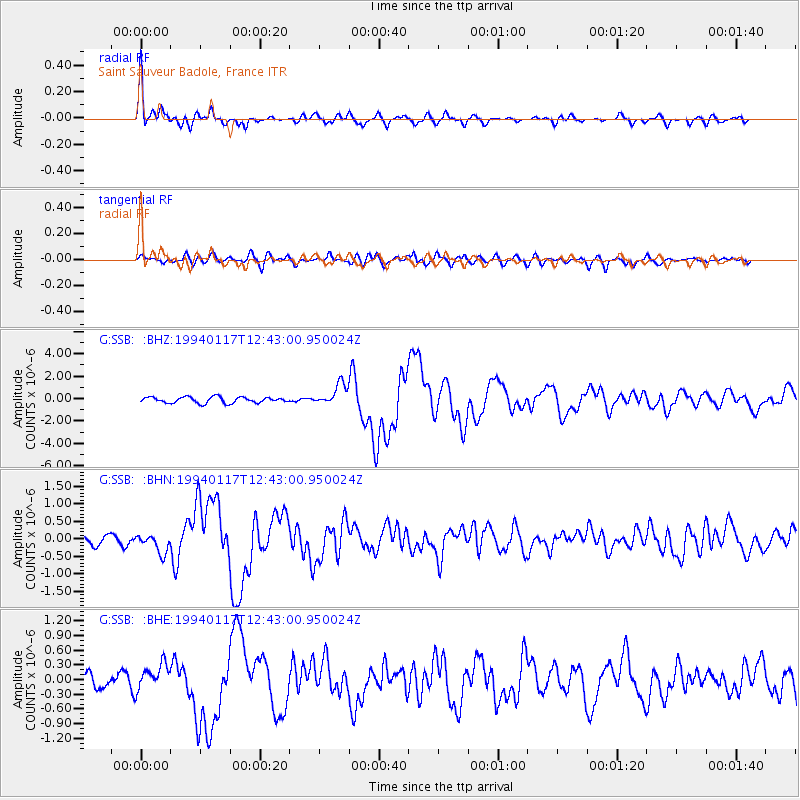
Signal To Noise
| Channel | StoN | STA | LTA |
| G:SSB: :BHN:19940117T12:43:00.950024Z | 2.085395 | 2.6905823E-7 | 1.2902026E-7 |
| G:SSB: :BHE:19940117T12:43:00.950024Z | 1.3714085 | 2.626777E-7 | 1.9153862E-7 |
| G:SSB: :BHZ:19940117T12:43:00.950024Z | 3.557586 | 9.4359217E-7 | 2.6523384E-7 |
| Arrivals |
| Ps | 3.5 SECOND |
| PpPs | 11 SECOND |
| PsPs/PpSs | 14 SECOND |


