You are here: Home > Network List > TA - USArray Transportable Network (new EarthScope stations) Stations List
> Station P47A Martinsville, IN, USA > Earthquake Result Viewer
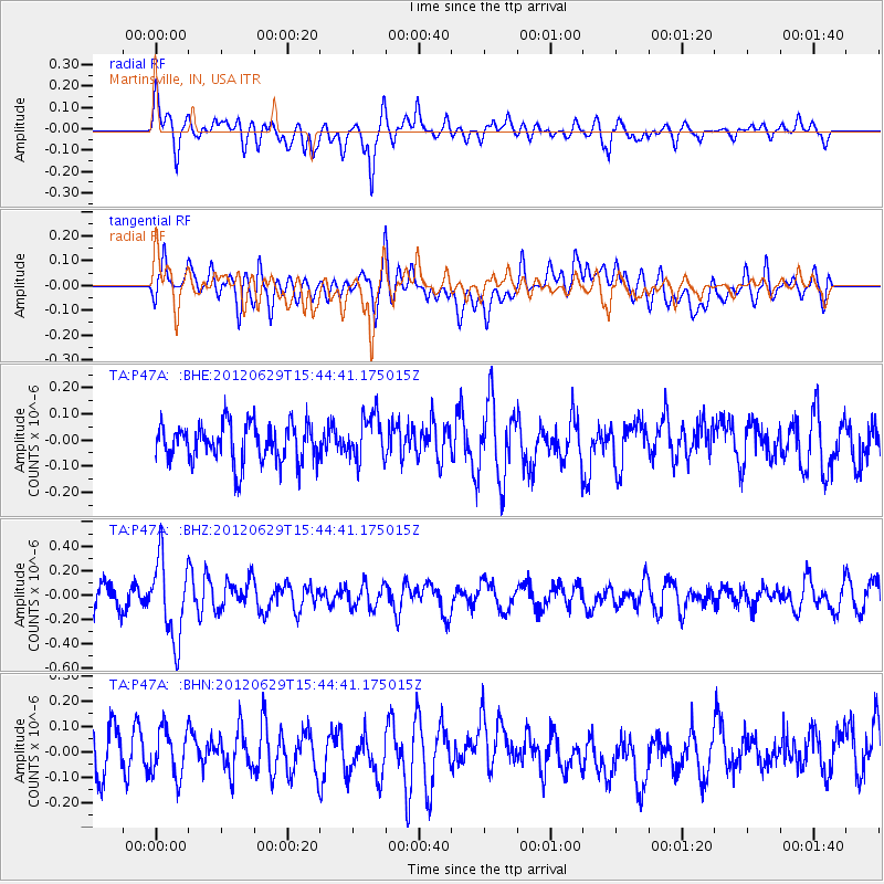
P47A Martinsville, IN, USA - Earthquake Result Viewer
*The percent match for this event was below the threshold and hence no stack was calculated.
| Earthquake location: |
South Atlantic Ocean |
| Earthquake latitude/longitude: |
-24.7/-9.7 |
| Earthquake time(UTC): |
2012/06/29 (181) 15:31:46 GMT |
| Earthquake Depth: |
10 km |
| Earthquake Magnitude: |
6.0 MB, 5.2 MS, 5.8 MW, 5.8 MW |
| Earthquake Catalog/Contributor: |
WHDF/NEIC |
|
| Network: |
TA USArray Transportable Network (new EarthScope stations) |
| Station: |
P47A Martinsville, IN, USA |
| Lat/Lon: |
39.49 N/86.27 W |
| Elevation: |
246 m |
|
| Distance: |
95.8 deg |
| Az: |
310.83 deg |
| Baz: |
117.25 deg |
| Ray Param: |
$rayparam |
*The percent match for this event was below the threshold and hence was not used in the summary stack. |
|
| Radial Match: |
63.4858 % |
| Radial Bump: |
400 |
| Transverse Match: |
47.80369 % |
| Transverse Bump: |
400 |
| SOD ConfigId: |
463687 |
| Insert Time: |
2013-02-20 16:49:16.862 +0000 |
| GWidth: |
2.5 |
| Max Bumps: |
400 |
| Tol: |
0.001 |
|
Signal To Noise
| Channel | StoN | STA | LTA |
| TA:P47A: :BHZ:20120629T15:44:41.175015Z | 2.9622319 | 3.2423011E-7 | 1.0945467E-7 |
| TA:P47A: :BHN:20120629T15:44:41.175015Z | 1.163018 | 9.54185E-8 | 8.204387E-8 |
| TA:P47A: :BHE:20120629T15:44:41.175015Z | 1.1968087 | 8.749842E-8 | 7.310978E-8 |
| Arrivals |
| Ps | |
| PpPs | |
| PsPs/PpSs | |


