You are here: Home > Network List > TA - USArray Transportable Network (new EarthScope stations) Stations List
> Station 352A Blakely, GA, USA > Earthquake Result Viewer
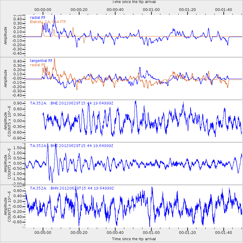
352A Blakely, GA, USA - Earthquake Result Viewer
*The percent match for this event was below the threshold and hence no stack was calculated.
| Earthquake location: |
South Atlantic Ocean |
| Earthquake latitude/longitude: |
-24.7/-9.7 |
| Earthquake time(UTC): |
2012/06/29 (181) 15:31:46 GMT |
| Earthquake Depth: |
10 km |
| Earthquake Magnitude: |
6.0 MB, 5.2 MS, 5.8 MW, 5.8 MW |
| Earthquake Catalog/Contributor: |
WHDF/NEIC |
|
| Network: |
TA USArray Transportable Network (new EarthScope stations) |
| Station: |
352A Blakely, GA, USA |
| Lat/Lon: |
31.48 N/84.93 W |
| Elevation: |
101 m |
|
| Distance: |
91.1 deg |
| Az: |
304.266 deg |
| Baz: |
118.42 deg |
| Ray Param: |
$rayparam |
*The percent match for this event was below the threshold and hence was not used in the summary stack. |
|
| Radial Match: |
47.96014 % |
| Radial Bump: |
400 |
| Transverse Match: |
43.515305 % |
| Transverse Bump: |
400 |
| SOD ConfigId: |
463687 |
| Insert Time: |
2013-02-20 16:54:09.486 +0000 |
| GWidth: |
2.5 |
| Max Bumps: |
400 |
| Tol: |
0.001 |
|
Signal To Noise
| Channel | StoN | STA | LTA |
| TA:352A: :BHZ:20120629T15:44:19.64999Z | 4.1513314 | 7.872437E-7 | 1.8963644E-7 |
| TA:352A: :BHN:20120629T15:44:19.64999Z | 0.7052127 | 1.9390309E-7 | 2.7495688E-7 |
| TA:352A: :BHE:20120629T15:44:19.64999Z | 1.4570646 | 3.911661E-7 | 2.6846175E-7 |
| Arrivals |
| Ps | |
| PpPs | |
| PsPs/PpSs | |


