You are here: Home > Network List > X812 - Deep Structure of Three Continental Sutures in Eastern North America Stations List
> Station QM15 Land Trust South, Maine, USA > Earthquake Result Viewer
QM15 Land Trust South, Maine, USA - Earthquake Result Viewer
| Earthquake location: |
Near Coast Of Guerrero, Mexico |
| Earthquake latitude/longitude: |
16.5/-98.1 |
| Earthquake time(UTC): |
2014/05/24 (144) 08:24:47 GMT |
| Earthquake Depth: |
17 km |
| Earthquake Magnitude: |
5.7 MWW, 5.6 MWB, 5.7 MWC |
| Earthquake Catalog/Contributor: |
NEIC PDE/NEIC COMCAT |
|
| Network: |
X8 Deep Structure of Three Continental Sutures in Eastern North America |
| Station: |
QM15 Land Trust South, Maine, USA |
| Lat/Lon: |
45.09 N/67.84 W |
| Elevation: |
151 m |
|
| Distance: |
38.2 deg |
| Az: |
35.329 deg |
| Baz: |
231.544 deg |
| Ray Param: |
0.07569808 |
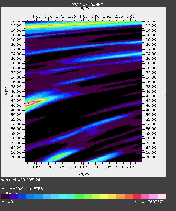
| Estimated Moho Depth: |
45.0 km |
| Estimated Crust Vp/Vs: |
1.62 |
| Assumed Crust Vp: |
6.419 km/s |
| Estimated Crust Vs: |
3.975 km/s |
| Estimated Crust Poisson's Ratio: |
0.19 |
|
| Radial Match: |
80.205124 % |
| Radial Bump: |
400 |
| Transverse Match: |
57.739597 % |
| Transverse Bump: |
400 |
| SOD ConfigId: |
3390531 |
| Insert Time: |
2019-04-12 00:41:35.069 +0000 |
| GWidth: |
2.5 |
| Max Bumps: |
400 |
| Tol: |
0.001 |
|

Signal To Noise
| Channel | StoN | STA | LTA |
| X8:QM15: :HHZ:20140524T08:31:35.900004Z | 2.6189878 | 4.5007488E-7 | 1.718507E-7 |
| X8:QM15: :HHN:20140524T08:31:35.900004Z | 1.3368584 | 1.875287E-7 | 1.4027566E-7 |
| X8:QM15: :HHE:20140524T08:31:35.900004Z | 2.187105 | 2.775931E-7 | 1.2692263E-7 |
| Arrivals |
| Ps | 4.7 SECOND |
| PpPs | 17 SECOND |
| PsPs/PpSs | 22 SECOND |


