You are here: Home > Network List > TA - USArray Transportable Network (new EarthScope stations) Stations List
> Station 356A Blackshear, GA, USA > Earthquake Result Viewer
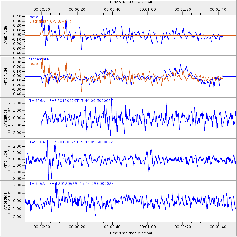
356A Blackshear, GA, USA - Earthquake Result Viewer
*The percent match for this event was below the threshold and hence no stack was calculated.
| Earthquake location: |
South Atlantic Ocean |
| Earthquake latitude/longitude: |
-24.7/-9.7 |
| Earthquake time(UTC): |
2012/06/29 (181) 15:31:46 GMT |
| Earthquake Depth: |
10 km |
| Earthquake Magnitude: |
6.0 MB, 5.2 MS, 5.8 MW, 5.8 MW |
| Earthquake Catalog/Contributor: |
WHDF/NEIC |
|
| Network: |
TA USArray Transportable Network (new EarthScope stations) |
| Station: |
356A Blackshear, GA, USA |
| Lat/Lon: |
31.32 N/82.13 W |
| Elevation: |
36 m |
|
| Distance: |
88.9 deg |
| Az: |
305.298 deg |
| Baz: |
119.873 deg |
| Ray Param: |
$rayparam |
*The percent match for this event was below the threshold and hence was not used in the summary stack. |
|
| Radial Match: |
55.678715 % |
| Radial Bump: |
400 |
| Transverse Match: |
43.271427 % |
| Transverse Bump: |
400 |
| SOD ConfigId: |
463687 |
| Insert Time: |
2013-02-20 16:54:56.839 +0000 |
| GWidth: |
2.5 |
| Max Bumps: |
400 |
| Tol: |
0.001 |
|
Signal To Noise
| Channel | StoN | STA | LTA |
| TA:356A: :BHZ:20120629T15:44:09.600002Z | 2.3231668 | 1.2178913E-6 | 5.242375E-7 |
| TA:356A: :BHN:20120629T15:44:09.600002Z | 0.7634101 | 3.6328632E-7 | 4.7587307E-7 |
| TA:356A: :BHE:20120629T15:44:09.600002Z | 1.2179466 | 7.0000885E-7 | 5.747451E-7 |
| Arrivals |
| Ps | |
| PpPs | |
| PsPs/PpSs | |


