You are here: Home > Network List > X812 - Deep Structure of Three Continental Sutures in Eastern North America Stations List
> Station QM58 Lac a Jim, Quebec, Canada > Earthquake Result Viewer
QM58 Lac a Jim, Quebec, Canada - Earthquake Result Viewer
| Earthquake location: |
Near Coast Of Guerrero, Mexico |
| Earthquake latitude/longitude: |
16.5/-98.1 |
| Earthquake time(UTC): |
2014/05/24 (144) 08:24:47 GMT |
| Earthquake Depth: |
17 km |
| Earthquake Magnitude: |
5.7 MWW, 5.6 MWB, 5.7 MWC |
| Earthquake Catalog/Contributor: |
NEIC PDE/NEIC COMCAT |
|
| Network: |
X8 Deep Structure of Three Continental Sutures in Eastern North America |
| Station: |
QM58 Lac a Jim, Quebec, Canada |
| Lat/Lon: |
49.05 N/72.74 W |
| Elevation: |
190 m |
|
| Distance: |
38.5 deg |
| Az: |
26.98 deg |
| Baz: |
221.41 deg |
| Ray Param: |
0.07552806 |
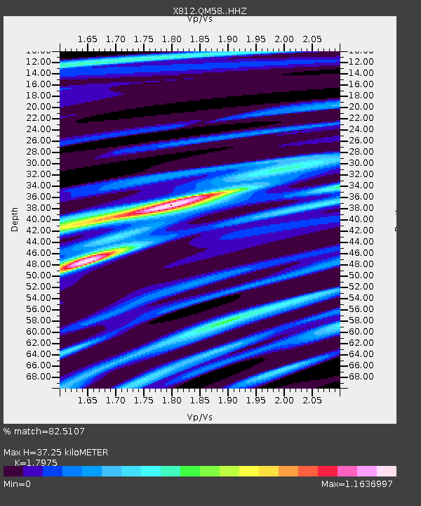
| Estimated Moho Depth: |
37.25 km |
| Estimated Crust Vp/Vs: |
1.80 |
| Assumed Crust Vp: |
6.61 km/s |
| Estimated Crust Vs: |
3.677 km/s |
| Estimated Crust Poisson's Ratio: |
0.28 |
|
| Radial Match: |
82.5107 % |
| Radial Bump: |
400 |
| Transverse Match: |
53.12453 % |
| Transverse Bump: |
400 |
| SOD ConfigId: |
3390531 |
| Insert Time: |
2019-04-12 00:41:41.941 +0000 |
| GWidth: |
2.5 |
| Max Bumps: |
400 |
| Tol: |
0.001 |
|

Signal To Noise
| Channel | StoN | STA | LTA |
| X8:QM58: :HHZ:20140524T08:31:38.289988Z | 6.815096 | 7.2003036E-7 | 1.0565227E-7 |
| X8:QM58: :HHN:20140524T08:31:38.289988Z | 1.8618678 | 2.8599482E-7 | 1.5360641E-7 |
| X8:QM58: :HHE:20140524T08:31:38.289988Z | 2.9665427 | 2.6729634E-7 | 9.0103654E-8 |
| Arrivals |
| Ps | 4.8 SECOND |
| PpPs | 15 SECOND |
| PsPs/PpSs | 19 SECOND |


