You are here: Home > Network List > TA - USArray Transportable Network (new EarthScope stations) Stations List
> Station Y54A Tignall, GA, USA > Earthquake Result Viewer
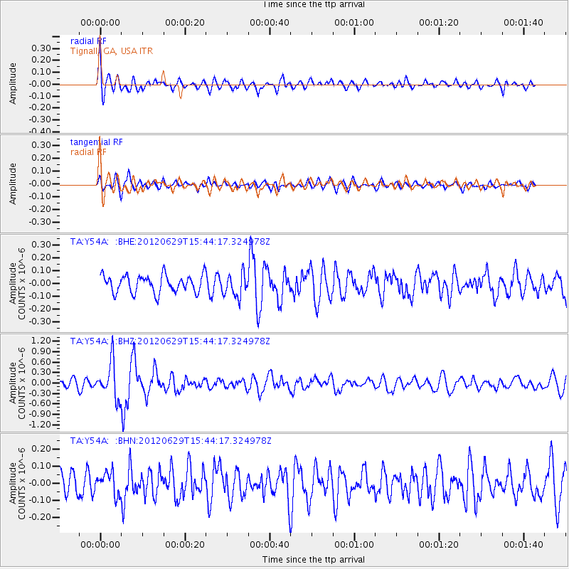
Y54A Tignall, GA, USA - Earthquake Result Viewer
*The percent match for this event was below the threshold and hence no stack was calculated.
| Earthquake location: |
South Atlantic Ocean |
| Earthquake latitude/longitude: |
-24.7/-9.7 |
| Earthquake time(UTC): |
2012/06/29 (181) 15:31:46 GMT |
| Earthquake Depth: |
10 km |
| Earthquake Magnitude: |
6.0 MB, 5.2 MS, 5.8 MW, 5.8 MW |
| Earthquake Catalog/Contributor: |
WHDF/NEIC |
|
| Network: |
TA USArray Transportable Network (new EarthScope stations) |
| Station: |
Y54A Tignall, GA, USA |
| Lat/Lon: |
33.86 N/82.69 W |
| Elevation: |
176 m |
|
| Distance: |
90.6 deg |
| Az: |
307.26 deg |
| Baz: |
119.581 deg |
| Ray Param: |
$rayparam |
*The percent match for this event was below the threshold and hence was not used in the summary stack. |
|
| Radial Match: |
70.48594 % |
| Radial Bump: |
400 |
| Transverse Match: |
66.43716 % |
| Transverse Bump: |
400 |
| SOD ConfigId: |
463687 |
| Insert Time: |
2013-02-20 16:56:20.157 +0000 |
| GWidth: |
2.5 |
| Max Bumps: |
400 |
| Tol: |
0.001 |
|
Signal To Noise
| Channel | StoN | STA | LTA |
| TA:Y54A: :BHZ:20120629T15:44:17.324978Z | 4.922965 | 5.296845E-7 | 1.0759461E-7 |
| TA:Y54A: :BHN:20120629T15:44:17.324978Z | 1.2157968 | 6.7768156E-8 | 5.57397E-8 |
| TA:Y54A: :BHE:20120629T15:44:17.324978Z | 1.3486105 | 9.118524E-8 | 6.761422E-8 |
| Arrivals |
| Ps | |
| PpPs | |
| PsPs/PpSs | |


