You are here: Home > Network List > G - GEOSCOPE Stations List
> Station SSB Saint Sauveur Badole, France > Earthquake Result Viewer
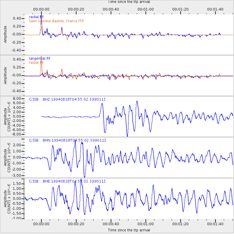
SSB Saint Sauveur Badole, France - Earthquake Result Viewer

| Earthquake location: |
East Of Kuril Islands |
| Earthquake latitude/longitude: |
44.7/150.2 |
| Earthquake time(UTC): |
1994/08/18 (230) 04:42:59 GMT |
| Earthquake Depth: |
33 km |
| Earthquake Magnitude: |
6.1 MB, 6.5 MS, 6.6 UNKNOWN, 6.5 MW |
| Earthquake Catalog/Contributor: |
WHDF/NEIC |
|
| Network: |
G GEOSCOPE |
| Station: |
SSB Saint Sauveur Badole, France |
| Lat/Lon: |
45.28 N/4.54 E |
| Elevation: |
700 m |
|
| Distance: |
85.4 deg |
| Az: |
336.43 deg |
| Baz: |
23.834 deg |
| Ray Param: |
0.044756304 |
| Estimated Moho Depth: |
24.0 km |
| Estimated Crust Vp/Vs: |
2.08 |
| Assumed Crust Vp: |
6.1 km/s |
| Estimated Crust Vs: |
2.929 km/s |
| Estimated Crust Poisson's Ratio: |
0.35 |
|
| Radial Match: |
98.15523 % |
| Radial Bump: |
264 |
| Transverse Match: |
89.13772 % |
| Transverse Bump: |
400 |
| SOD ConfigId: |
17000 |
| Insert Time: |
2010-02-27 00:08:59.915 +0000 |
| GWidth: |
2.5 |
| Max Bumps: |
400 |
| Tol: |
0.001 |
|
Signal To Noise
| Channel | StoN | STA | LTA |
| G:SSB: :BHN:19940818T04:55:02.399011Z | 7.370224 | 5.830377E-7 | 7.910719E-8 |
| G:SSB: :BHE:19940818T04:55:02.399011Z | 4.1074505 | 3.809086E-7 | 9.273602E-8 |
| G:SSB: :BHZ:19940818T04:55:02.399011Z | 13.4803505 | 1.867306E-6 | 1.3852059E-7 |
| Arrivals |
| Ps | 4.3 SECOND |
| PpPs | 12 SECOND |
| PsPs/PpSs | 16 SECOND |


