You are here: Home > Network List > G - GEOSCOPE Stations List
> Station SSB Saint Sauveur Badole, France > Earthquake Result Viewer
SSB Saint Sauveur Badole, France - Earthquake Result Viewer
| Earthquake location: |
Kuril Islands |
| Earthquake latitude/longitude: |
43.7/147.3 |
| Earthquake time(UTC): |
1994/10/04 (277) 13:22:58 GMT |
| Earthquake Depth: |
33 km |
| Earthquake Magnitude: |
7.4 MB, 8.1 MS, 8.3 UNKNOWN, 8.2 MW |
| Earthquake Catalog/Contributor: |
WHDF/NEIC |
|
| Network: |
G GEOSCOPE |
| Station: |
SSB Saint Sauveur Badole, France |
| Lat/Lon: |
45.28 N/4.54 E |
| Elevation: |
700 m |
|
| Distance: |
85.4 deg |
| Az: |
334.636 deg |
| Baz: |
26.104 deg |
| Ray Param: |
0.04473329 |
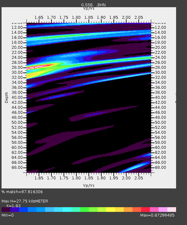
| Estimated Moho Depth: |
27.75 km |
| Estimated Crust Vp/Vs: |
1.63 |
| Assumed Crust Vp: |
6.1 km/s |
| Estimated Crust Vs: |
3.742 km/s |
| Estimated Crust Poisson's Ratio: |
0.20 |
|
| Radial Match: |
97.916306 % |
| Radial Bump: |
292 |
| Transverse Match: |
89.842834 % |
| Transverse Bump: |
400 |
| SOD ConfigId: |
17000 |
| Insert Time: |
2010-02-27 00:09:04.759 +0000 |
| GWidth: |
2.5 |
| Max Bumps: |
400 |
| Tol: |
0.001 |
|

Signal To Noise
| Channel | StoN | STA | LTA |
| G:SSB: :BHN:19941004T13:35:01.250012Z | 3.4285183 | 1.4311087E-6 | 4.1741316E-7 |
| G:SSB: :BHE:19941004T13:35:01.250012Z | 2.931183 | 1.0720078E-6 | 3.6572527E-7 |
| G:SSB: :BHZ:19941004T13:35:01.250012Z | 5.177105 | 6.3833763E-6 | 1.2330012E-6 |
| Arrivals |
| Ps | 2.9 SECOND |
| PpPs | 12 SECOND |
| PsPs/PpSs | 15 SECOND |


