You are here: Home > Network List > KN - Kyrgyz Seismic Telemetry Network Stations List
> Station KZA KN.KZA > Earthquake Result Viewer
KZA KN.KZA - Earthquake Result Viewer
| Earthquake location: |
Aegean Sea |
| Earthquake latitude/longitude: |
40.3/25.5 |
| Earthquake time(UTC): |
2014/05/24 (144) 09:25:03 GMT |
| Earthquake Depth: |
10 km |
| Earthquake Magnitude: |
6.4 MWP, 6.4 M |
| Earthquake Catalog/Contributor: |
NEIC PDE/NEIC ALERT |
|
| Network: |
KN Kyrgyz Seismic Telemetry Network |
| Station: |
KZA KN.KZA |
| Lat/Lon: |
42.08 N/75.25 E |
| Elevation: |
3520 m |
|
| Distance: |
37.1 deg |
| Az: |
70.545 deg |
| Baz: |
284.424 deg |
| Ray Param: |
0.07632708 |
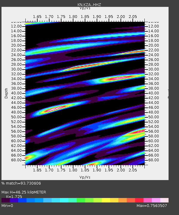
| Estimated Moho Depth: |
46.25 km |
| Estimated Crust Vp/Vs: |
1.73 |
| Assumed Crust Vp: |
6.306 km/s |
| Estimated Crust Vs: |
3.656 km/s |
| Estimated Crust Poisson's Ratio: |
0.25 |
|
| Radial Match: |
93.730606 % |
| Radial Bump: |
390 |
| Transverse Match: |
78.0109 % |
| Transverse Bump: |
350 |
| SOD ConfigId: |
3390531 |
| Insert Time: |
2019-04-12 00:44:24.629 +0000 |
| GWidth: |
2.5 |
| Max Bumps: |
400 |
| Tol: |
0.001 |
|
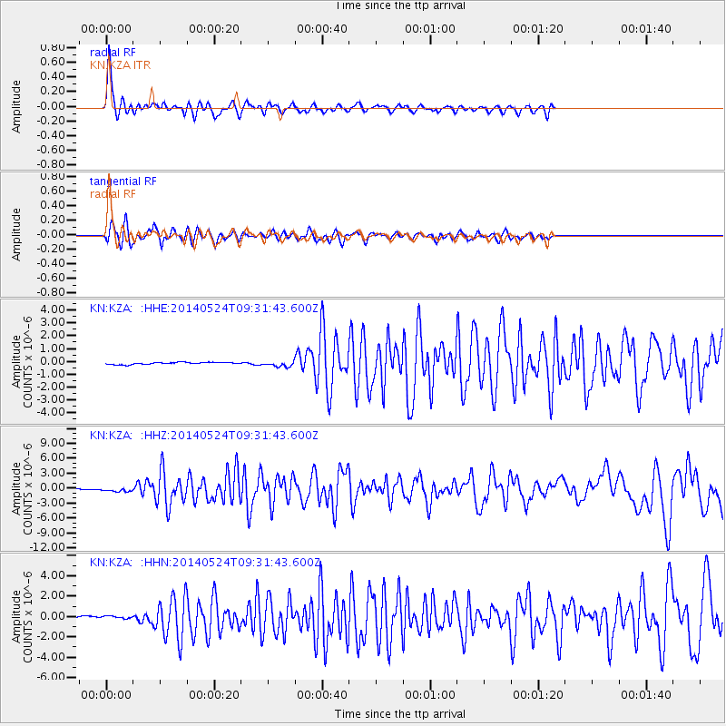
Signal To Noise
| Channel | StoN | STA | LTA |
| KN:KZA: :HHZ:20140524T09:31:43.600Z | 1.8481967 | 2.871081E-7 | 1.5534499E-7 |
| KN:KZA: :HHN:20140524T09:31:43.600Z | 1.5228335 | 1.6302644E-7 | 1.07054674E-7 |
| KN:KZA: :HHE:20140524T09:31:43.600Z | 2.5476902 | 2.0312444E-7 | 7.9728856E-8 |
| Arrivals |
| Ps | 5.7 SECOND |
| PpPs | 19 SECOND |
| PsPs/PpSs | 24 SECOND |


