You are here: Home > Network List > G - GEOSCOPE Stations List
> Station SSB Saint Sauveur Badole, France > Earthquake Result Viewer
SSB Saint Sauveur Badole, France - Earthquake Result Viewer
| Earthquake location: |
Chiapas, Mexico |
| Earthquake latitude/longitude: |
16.9/-93.5 |
| Earthquake time(UTC): |
1995/10/21 (294) 02:38:57 GMT |
| Earthquake Depth: |
161 km |
| Earthquake Magnitude: |
6.2 MB, 7.3 UNKNOWN, 7.3 MW |
| Earthquake Catalog/Contributor: |
WHDF/NEIC |
|
| Network: |
G GEOSCOPE |
| Station: |
SSB Saint Sauveur Badole, France |
| Lat/Lon: |
45.28 N/4.54 E |
| Elevation: |
700 m |
|
| Distance: |
83.7 deg |
| Az: |
44.707 deg |
| Baz: |
287.457 deg |
| Ray Param: |
0.045659427 |
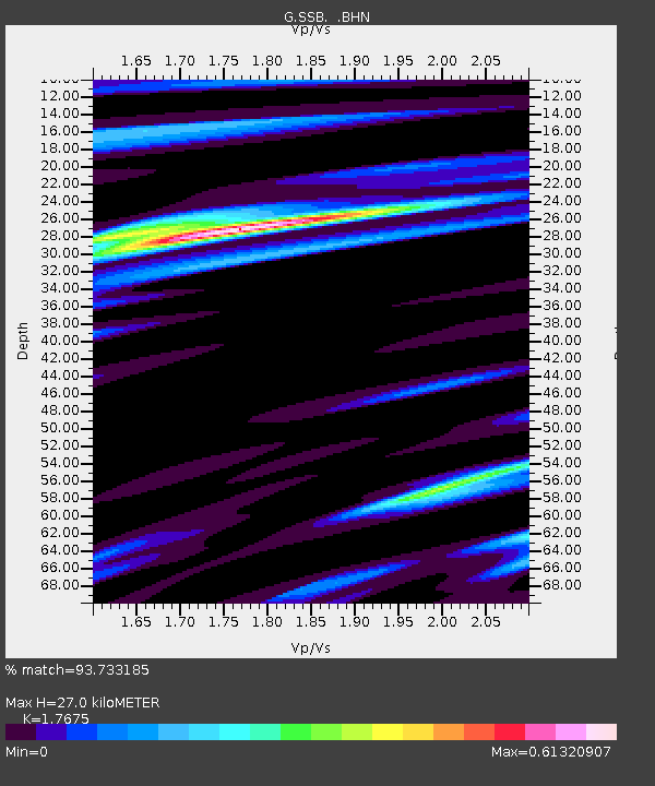
| Estimated Moho Depth: |
27.0 km |
| Estimated Crust Vp/Vs: |
1.77 |
| Assumed Crust Vp: |
6.1 km/s |
| Estimated Crust Vs: |
3.451 km/s |
| Estimated Crust Poisson's Ratio: |
0.26 |
|
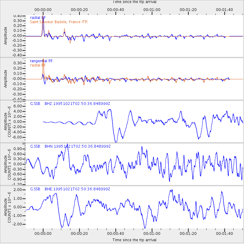
| Radial Match: |
93.733185 % |
| Radial Bump: |
353 |
| Transverse Match: |
66.6192 % |
| Transverse Bump: |
400 |
| SOD ConfigId: |
6273 |
| Insert Time: |
2010-02-27 00:09:18.527 +0000 |
| GWidth: |
2.5 |
| Max Bumps: |
400 |
| Tol: |
0.001 |
|
Signal To Noise
| Channel | StoN | STA | LTA |
| G:SSB: :BHN:19951021T02:50:36.848999Z | 2.4299126 | 4.5911645E-7 | 1.8894362E-7 |
| G:SSB: :BHE:19951021T02:50:36.848999Z | 6.554657 | 1.0193036E-6 | 1.555083E-7 |
| G:SSB: :BHZ:19951021T02:50:36.848999Z | 9.52922 | 3.256567E-6 | 3.417454E-7 |
| Arrivals |
| Ps | 3.5 SECOND |
| PpPs | 12 SECOND |
| PsPs/PpSs | 15 SECOND |


