You are here: Home > Network List > TA - USArray Transportable Network (new EarthScope stations) Stations List
> Station F62A Pittston Farm, Pittston Academy Grant, ME, USA > Earthquake Result Viewer
F62A Pittston Farm, Pittston Academy Grant, ME, USA - Earthquake Result Viewer
| Earthquake location: |
Aegean Sea |
| Earthquake latitude/longitude: |
40.3/25.5 |
| Earthquake time(UTC): |
2014/05/24 (144) 09:25:03 GMT |
| Earthquake Depth: |
10 km |
| Earthquake Magnitude: |
6.4 MWP, 6.4 M |
| Earthquake Catalog/Contributor: |
NEIC PDE/NEIC ALERT |
|
| Network: |
TA USArray Transportable Network (new EarthScope stations) |
| Station: |
F62A Pittston Farm, Pittston Academy Grant, ME, USA |
| Lat/Lon: |
45.90 N/69.97 W |
| Elevation: |
331 m |
|
| Distance: |
65.7 deg |
| Az: |
310.31 deg |
| Baz: |
56.611 deg |
| Ray Param: |
0.058070924 |
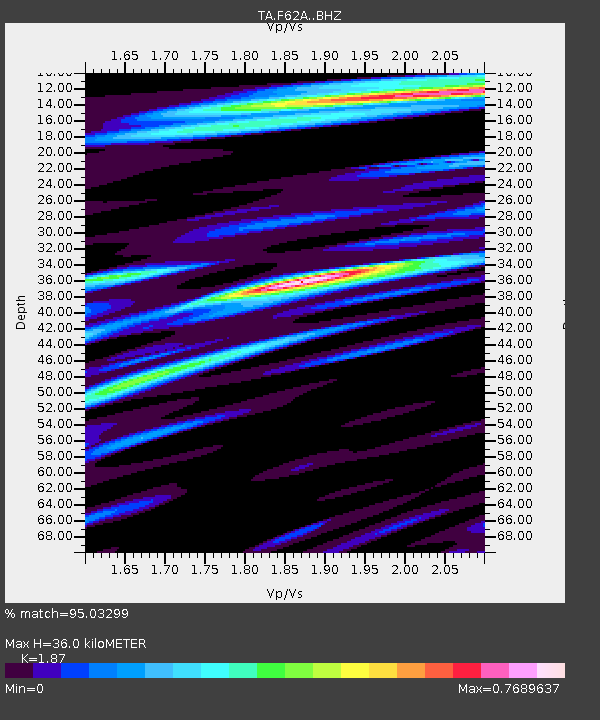
| Estimated Moho Depth: |
36.0 km |
| Estimated Crust Vp/Vs: |
1.87 |
| Assumed Crust Vp: |
6.419 km/s |
| Estimated Crust Vs: |
3.433 km/s |
| Estimated Crust Poisson's Ratio: |
0.30 |
|
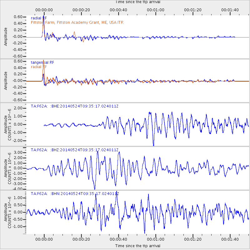
| Radial Match: |
95.03299 % |
| Radial Bump: |
351 |
| Transverse Match: |
88.32326 % |
| Transverse Bump: |
400 |
| SOD ConfigId: |
3390531 |
| Insert Time: |
2019-04-12 00:46:17.849 +0000 |
| GWidth: |
2.5 |
| Max Bumps: |
400 |
| Tol: |
0.001 |
|
Signal To Noise
| Channel | StoN | STA | LTA |
| TA:F62A: :BHZ:20140524T09:35:17.024011Z | 4.565701 | 6.0808355E-7 | 1.3318515E-7 |
| TA:F62A: :BHN:20140524T09:35:17.024011Z | 1.4341311 | 1.3336609E-7 | 9.299434E-8 |
| TA:F62A: :BHE:20140524T09:35:17.024011Z | 3.43932 | 4.1334792E-7 | 1.2018303E-7 |
| Arrivals |
| Ps | 5.1 SECOND |
| PpPs | 15 SECOND |
| PsPs/PpSs | 21 SECOND |


