You are here: Home > Network List > US - United States National Seismic Network Stations List
> Station BOZ Bozeman, Montana, USA > Earthquake Result Viewer
BOZ Bozeman, Montana, USA - Earthquake Result Viewer

| Earthquake location: |
Aegean Sea |
| Earthquake latitude/longitude: |
40.3/25.5 |
| Earthquake time(UTC): |
2014/05/24 (144) 09:25:03 GMT |
| Earthquake Depth: |
10 km |
| Earthquake Magnitude: |
6.4 MWP, 6.4 M |
| Earthquake Catalog/Contributor: |
NEIC PDE/NEIC ALERT |
|
| Network: |
US United States National Seismic Network |
| Station: |
BOZ Bozeman, Montana, USA |
| Lat/Lon: |
45.65 N/111.63 W |
| Elevation: |
1589 m |
|
| Distance: |
86.2 deg |
| Az: |
331.398 deg |
| Baz: |
31.456 deg |
| Ray Param: |
0.04422855 |
| Estimated Moho Depth: |
35.25 km |
| Estimated Crust Vp/Vs: |
1.73 |
| Assumed Crust Vp: |
6.35 km/s |
| Estimated Crust Vs: |
3.665 km/s |
| Estimated Crust Poisson's Ratio: |
0.25 |
|
| Radial Match: |
95.40395 % |
| Radial Bump: |
314 |
| Transverse Match: |
89.62953 % |
| Transverse Bump: |
373 |
| SOD ConfigId: |
3390531 |
| Insert Time: |
2019-04-12 00:47:09.613 +0000 |
| GWidth: |
2.5 |
| Max Bumps: |
400 |
| Tol: |
0.001 |
|
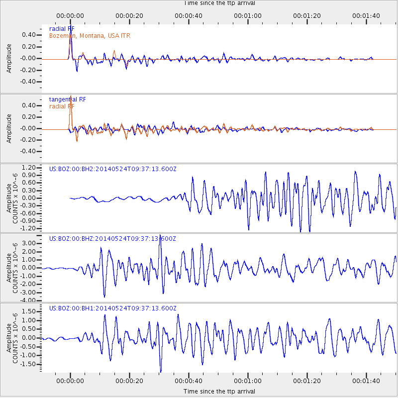
Signal To Noise
| Channel | StoN | STA | LTA |
| US:BOZ:00:BHZ:20140524T09:37:13.600Z | 7.07407 | 2.3296647E-7 | 3.293245E-8 |
| US:BOZ:00:BH1:20140524T09:37:13.600Z | 1.5719779 | 9.5108106E-8 | 6.0502195E-8 |
| US:BOZ:00:BH2:20140524T09:37:13.600Z | 1.2300715 | 7.891781E-8 | 6.415709E-8 |
| Arrivals |
| Ps | 4.2 SECOND |
| PpPs | 15 SECOND |
| PsPs/PpSs | 19 SECOND |


