You are here: Home > Network List > X812 - Deep Structure of Three Continental Sutures in Eastern North America Stations List
> Station QM30 Fish River Lake, Maine, USA > Earthquake Result Viewer
QM30 Fish River Lake, Maine, USA - Earthquake Result Viewer
| Earthquake location: |
Aegean Sea |
| Earthquake latitude/longitude: |
40.3/25.5 |
| Earthquake time(UTC): |
2014/05/24 (144) 09:25:03 GMT |
| Earthquake Depth: |
10 km |
| Earthquake Magnitude: |
6.4 MWP, 6.4 M |
| Earthquake Catalog/Contributor: |
NEIC PDE/NEIC ALERT |
|
| Network: |
X8 Deep Structure of Three Continental Sutures in Eastern North America |
| Station: |
QM30 Fish River Lake, Maine, USA |
| Lat/Lon: |
46.83 N/68.76 W |
| Elevation: |
262 m |
|
| Distance: |
64.5 deg |
| Az: |
310.677 deg |
| Baz: |
57.635 deg |
| Ray Param: |
0.058859844 |
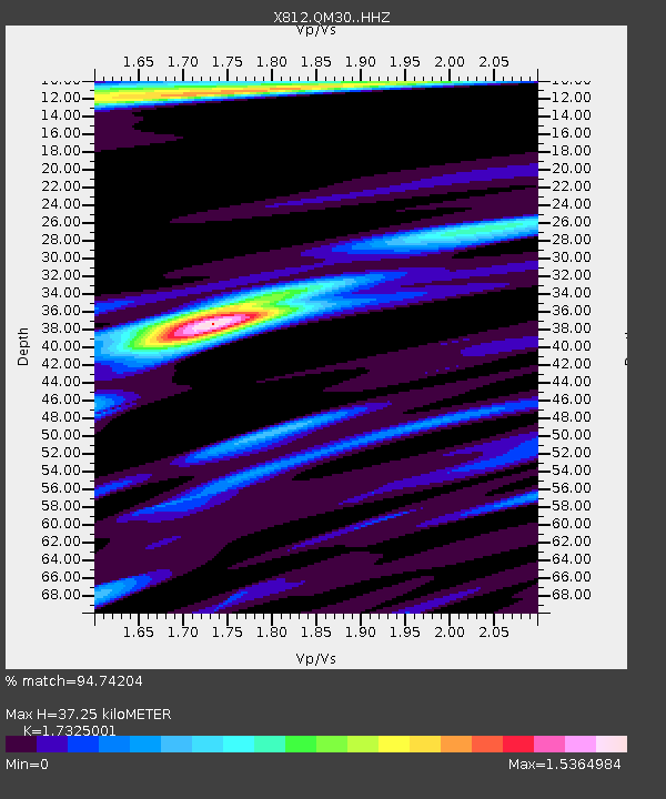
| Estimated Moho Depth: |
37.25 km |
| Estimated Crust Vp/Vs: |
1.73 |
| Assumed Crust Vp: |
6.419 km/s |
| Estimated Crust Vs: |
3.705 km/s |
| Estimated Crust Poisson's Ratio: |
0.25 |
|
| Radial Match: |
94.74204 % |
| Radial Bump: |
351 |
| Transverse Match: |
80.80698 % |
| Transverse Bump: |
400 |
| SOD ConfigId: |
3390531 |
| Insert Time: |
2019-04-12 00:47:43.569 +0000 |
| GWidth: |
2.5 |
| Max Bumps: |
400 |
| Tol: |
0.001 |
|

Signal To Noise
| Channel | StoN | STA | LTA |
| X8:QM30: :HHZ:20140524T09:35:09.190027Z | 2.5728753 | 5.9338635E-7 | 2.3063161E-7 |
| X8:QM30: :HHN:20140524T09:35:09.190027Z | 0.91942555 | 1.2200628E-7 | 1.3269839E-7 |
| X8:QM30: :HHE:20140524T09:35:09.190027Z | 1.5499139 | 1.6406192E-7 | 1.0585228E-7 |
| Arrivals |
| Ps | 4.4 SECOND |
| PpPs | 15 SECOND |
| PsPs/PpSs | 20 SECOND |


