You are here: Home > Network List > X812 - Deep Structure of Three Continental Sutures in Eastern North America Stations List
> Station QM28 6 mile checkpoint, Maine, USA > Earthquake Result Viewer
QM28 6 mile checkpoint, Maine, USA - Earthquake Result Viewer
| Earthquake location: |
Aegean Sea |
| Earthquake latitude/longitude: |
40.3/25.5 |
| Earthquake time(UTC): |
2014/05/24 (144) 09:25:03 GMT |
| Earthquake Depth: |
10 km |
| Earthquake Magnitude: |
6.4 MWP, 6.4 M |
| Earthquake Catalog/Contributor: |
NEIC PDE/NEIC ALERT |
|
| Network: |
X8 Deep Structure of Three Continental Sutures in Eastern North America |
| Station: |
QM28 6 mile checkpoint, Maine, USA |
| Lat/Lon: |
46.64 N/68.53 W |
| Elevation: |
212 m |
|
| Distance: |
64.5 deg |
| Az: |
310.397 deg |
| Baz: |
57.684 deg |
| Ray Param: |
0.05887901 |
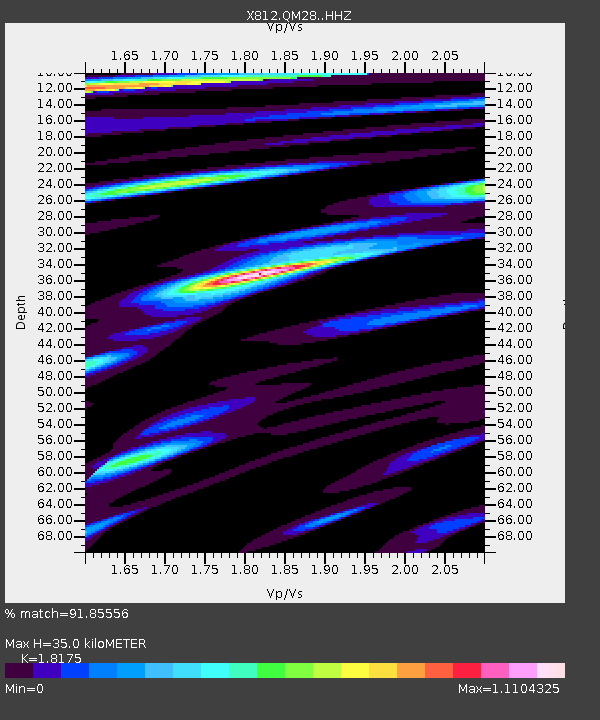
| Estimated Moho Depth: |
35.0 km |
| Estimated Crust Vp/Vs: |
1.82 |
| Assumed Crust Vp: |
6.419 km/s |
| Estimated Crust Vs: |
3.532 km/s |
| Estimated Crust Poisson's Ratio: |
0.28 |
|
| Radial Match: |
91.85556 % |
| Radial Bump: |
400 |
| Transverse Match: |
76.10635 % |
| Transverse Bump: |
400 |
| SOD ConfigId: |
3390531 |
| Insert Time: |
2019-04-12 00:47:44.082 +0000 |
| GWidth: |
2.5 |
| Max Bumps: |
400 |
| Tol: |
0.001 |
|

Signal To Noise
| Channel | StoN | STA | LTA |
| X8:QM28: :HHZ:20140524T09:35:08.99502Z | 2.8689485 | 4.7899937E-7 | 1.669599E-7 |
| X8:QM28: :HHN:20140524T09:35:08.99502Z | 1.4920707 | 2.592039E-7 | 1.7372092E-7 |
| X8:QM28: :HHE:20140524T09:35:08.99502Z | 2.1268055 | 2.4570832E-7 | 1.15529275E-7 |
| Arrivals |
| Ps | 4.6 SECOND |
| PpPs | 15 SECOND |
| PsPs/PpSs | 19 SECOND |


