You are here: Home > Network List > X812 - Deep Structure of Three Continental Sutures in Eastern North America Stations List
> Station QM31 Togue Pond, Maine, USA > Earthquake Result Viewer
QM31 Togue Pond, Maine, USA - Earthquake Result Viewer
| Earthquake location: |
Aegean Sea |
| Earthquake latitude/longitude: |
40.3/25.5 |
| Earthquake time(UTC): |
2014/05/24 (144) 09:25:03 GMT |
| Earthquake Depth: |
10 km |
| Earthquake Magnitude: |
6.4 MWP, 6.4 M |
| Earthquake Catalog/Contributor: |
NEIC PDE/NEIC ALERT |
|
| Network: |
X8 Deep Structure of Three Continental Sutures in Eastern North America |
| Station: |
QM31 Togue Pond, Maine, USA |
| Lat/Lon: |
46.93 N/68.89 W |
| Elevation: |
0.0 m |
|
| Distance: |
64.6 deg |
| Az: |
310.821 deg |
| Baz: |
57.607 deg |
| Ray Param: |
0.058848094 |
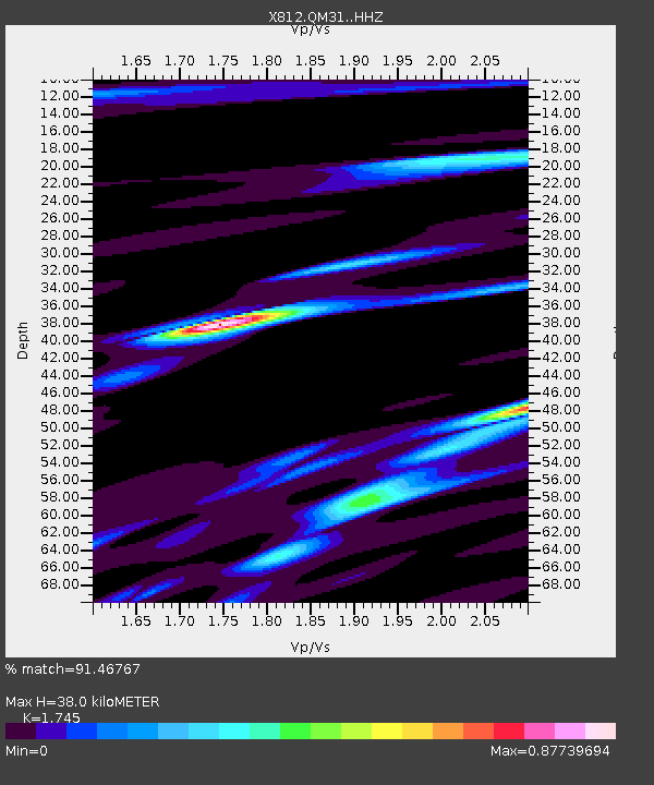
| Estimated Moho Depth: |
38.0 km |
| Estimated Crust Vp/Vs: |
1.75 |
| Assumed Crust Vp: |
6.419 km/s |
| Estimated Crust Vs: |
3.679 km/s |
| Estimated Crust Poisson's Ratio: |
0.26 |
|
| Radial Match: |
91.46767 % |
| Radial Bump: |
400 |
| Transverse Match: |
56.804928 % |
| Transverse Bump: |
400 |
| SOD ConfigId: |
3390531 |
| Insert Time: |
2019-04-12 00:47:44.006 +0000 |
| GWidth: |
2.5 |
| Max Bumps: |
400 |
| Tol: |
0.001 |
|

Signal To Noise
| Channel | StoN | STA | LTA |
| X8:QM31: :HHZ:20140524T09:35:09.319971Z | 3.3335197 | 5.3841256E-7 | 1.6151475E-7 |
| X8:QM31: :HHN:20140524T09:35:09.319971Z | 1.4560816 | 1.6363535E-7 | 1.1238062E-7 |
| X8:QM31: :HHE:20140524T09:35:09.319971Z | 2.4918191 | 2.818104E-7 | 1.1309424E-7 |
| Arrivals |
| Ps | 4.6 SECOND |
| PpPs | 16 SECOND |
| PsPs/PpSs | 20 SECOND |


