You are here: Home > Network List > GE - GEOFON Stations List
> Station EIL GEOFON Station Eilat, Israel > Earthquake Result Viewer
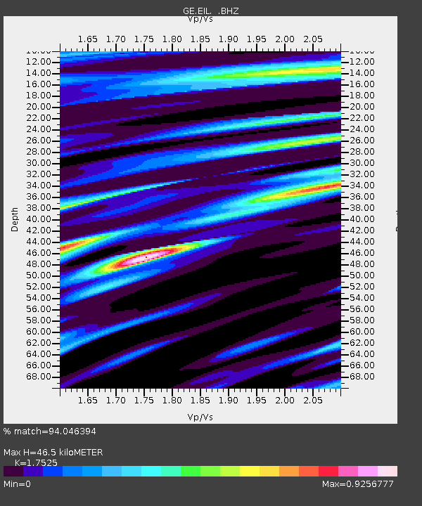
EIL GEOFON Station Eilat, Israel - Earthquake Result Viewer
| Earthquake location: |
Northern Xinjiang, China |
| Earthquake latitude/longitude: |
43.4/84.7 |
| Earthquake time(UTC): |
2012/06/29 (181) 21:07:33 GMT |
| Earthquake Depth: |
18 km |
| Earthquake Magnitude: |
6.2 MB, 6.4 MS, 6.3 MW, 6.3 MW |
| Earthquake Catalog/Contributor: |
WHDF/NEIC |
|
| Network: |
GE GEOFON |
| Station: |
EIL GEOFON Station Eilat, Israel |
| Lat/Lon: |
29.67 N/34.95 E |
| Elevation: |
210 m |
|
| Distance: |
41.7 deg |
| Az: |
267.718 deg |
| Baz: |
56.758 deg |
| Ray Param: |
0.073627464 |
| Estimated Moho Depth: |
46.5 km |
| Estimated Crust Vp/Vs: |
1.75 |
| Assumed Crust Vp: |
6.472 km/s |
| Estimated Crust Vs: |
3.693 km/s |
| Estimated Crust Poisson's Ratio: |
0.26 |
|
| Radial Match: |
94.046394 % |
| Radial Bump: |
400 |
| Transverse Match: |
81.88623 % |
| Transverse Bump: |
400 |
| SOD ConfigId: |
463687 |
| Insert Time: |
2013-02-20 17:06:41.149 +0000 |
| GWidth: |
2.5 |
| Max Bumps: |
400 |
| Tol: |
0.001 |
|

Signal To Noise
| Channel | StoN | STA | LTA |
| GE:EIL: :BHZ:20120629T21:14:50.400009Z | 40.650078 | 3.2667292E-6 | 8.036219E-8 |
| GE:EIL: :BHN:20120629T21:14:50.400009Z | 12.073262 | 9.866982E-7 | 8.1725894E-8 |
| GE:EIL: :BHE:20120629T21:14:50.400009Z | 17.994284 | 1.3882851E-6 | 7.7151455E-8 |
| Arrivals |
| Ps | 5.8 SECOND |
| PpPs | 18 SECOND |
| PsPs/PpSs | 24 SECOND |


