You are here: Home > Network List > X812 - Deep Structure of Three Continental Sutures in Eastern North America Stations List
> Station QM58 Lac a Jim, Quebec, Canada > Earthquake Result Viewer
QM58 Lac a Jim, Quebec, Canada - Earthquake Result Viewer
| Earthquake location: |
Aegean Sea |
| Earthquake latitude/longitude: |
40.3/25.5 |
| Earthquake time(UTC): |
2014/05/24 (144) 09:25:03 GMT |
| Earthquake Depth: |
10 km |
| Earthquake Magnitude: |
6.4 MWP, 6.4 M |
| Earthquake Catalog/Contributor: |
NEIC PDE/NEIC ALERT |
|
| Network: |
X8 Deep Structure of Three Continental Sutures in Eastern North America |
| Station: |
QM58 Lac a Jim, Quebec, Canada |
| Lat/Lon: |
49.05 N/72.74 W |
| Elevation: |
190 m |
|
| Distance: |
65.6 deg |
| Az: |
314.335 deg |
| Baz: |
56.232 deg |
| Ray Param: |
0.05818625 |
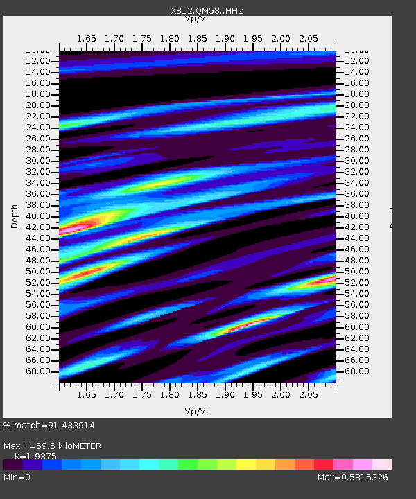
| Estimated Moho Depth: |
59.5 km |
| Estimated Crust Vp/Vs: |
1.94 |
| Assumed Crust Vp: |
6.61 km/s |
| Estimated Crust Vs: |
3.412 km/s |
| Estimated Crust Poisson's Ratio: |
0.32 |
|
| Radial Match: |
91.433914 % |
| Radial Bump: |
296 |
| Transverse Match: |
75.747 % |
| Transverse Bump: |
400 |
| SOD ConfigId: |
3390531 |
| Insert Time: |
2019-04-12 00:47:49.016 +0000 |
| GWidth: |
2.5 |
| Max Bumps: |
400 |
| Tol: |
0.001 |
|

Signal To Noise
| Channel | StoN | STA | LTA |
| X8:QM58: :HHZ:20140524T09:35:15.930017Z | 3.1268253 | 5.104335E-7 | 1.6324337E-7 |
| X8:QM58: :HHN:20140524T09:35:15.930017Z | 1.5121025 | 1.746131E-7 | 1.1547702E-7 |
| X8:QM58: :HHE:20140524T09:35:15.930017Z | 1.2093338 | 2.3100436E-7 | 1.9101786E-7 |
| Arrivals |
| Ps | 8.8 SECOND |
| PpPs | 25 SECOND |
| PsPs/PpSs | 34 SECOND |


