You are here: Home > Network List > XO11 - Ozark Illinois, Indiana and Kentucky ES Flexible Array Stations List
> Station KG29 KG29 of OIINK Flexarray > Earthquake Result Viewer
KG29 KG29 of OIINK Flexarray - Earthquake Result Viewer
| Earthquake location: |
Aegean Sea |
| Earthquake latitude/longitude: |
40.3/25.5 |
| Earthquake time(UTC): |
2014/05/24 (144) 09:25:03 GMT |
| Earthquake Depth: |
10 km |
| Earthquake Magnitude: |
6.4 MWP, 6.4 M |
| Earthquake Catalog/Contributor: |
NEIC PDE/NEIC ALERT |
|
| Network: |
XO Ozark Illinois, Indiana and Kentucky ES Flexible Array |
| Station: |
KG29 KG29 of OIINK Flexarray |
| Lat/Lon: |
37.72 N/87.47 W |
| Elevation: |
129 m |
|
| Distance: |
81.0 deg |
| Az: |
312.313 deg |
| Baz: |
45.483 deg |
| Ray Param: |
0.047892146 |
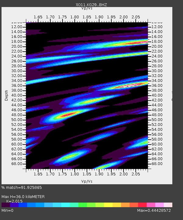
| Estimated Moho Depth: |
36.0 km |
| Estimated Crust Vp/Vs: |
2.02 |
| Assumed Crust Vp: |
6.444 km/s |
| Estimated Crust Vs: |
3.198 km/s |
| Estimated Crust Poisson's Ratio: |
0.34 |
|
| Radial Match: |
91.925865 % |
| Radial Bump: |
400 |
| Transverse Match: |
71.113464 % |
| Transverse Bump: |
400 |
| SOD ConfigId: |
3390531 |
| Insert Time: |
2019-04-12 00:48:23.880 +0000 |
| GWidth: |
2.5 |
| Max Bumps: |
400 |
| Tol: |
0.001 |
|

Signal To Noise
| Channel | StoN | STA | LTA |
| XO:KG29: :BHZ:20140524T09:36:46.759973Z | 4.272429 | 4.0145864E-7 | 9.3964964E-8 |
| XO:KG29: :BHN:20140524T09:36:46.759973Z | 1.4924242 | 1.8477944E-7 | 1.238116E-7 |
| XO:KG29: :BHE:20140524T09:36:46.759973Z | 0.5898189 | 7.901605E-8 | 1.3396664E-7 |
| Arrivals |
| Ps | 5.8 SECOND |
| PpPs | 16 SECOND |
| PsPs/PpSs | 22 SECOND |


