You are here: Home > Network List > PL - Polish Seismological Network Stations List
> Station KWP PLSN/GEOFON Station Kalwaria Paclawska, Poland > Earthquake Result Viewer
KWP PLSN/GEOFON Station Kalwaria Paclawska, Poland - Earthquake Result Viewer
| Earthquake location: |
Northern Xinjiang, China |
| Earthquake latitude/longitude: |
43.4/84.7 |
| Earthquake time(UTC): |
2012/06/29 (181) 21:07:33 GMT |
| Earthquake Depth: |
18 km |
| Earthquake Magnitude: |
6.2 MB, 6.4 MS, 6.3 MW, 6.3 MW |
| Earthquake Catalog/Contributor: |
WHDF/NEIC |
|
| Network: |
PL Polish Seismological Network |
| Station: |
KWP PLSN/GEOFON Station Kalwaria Paclawska, Poland |
| Lat/Lon: |
49.63 N/22.71 E |
| Elevation: |
448 m |
|
| Distance: |
42.0 deg |
| Az: |
300.952 deg |
| Baz: |
73.907 deg |
| Ray Param: |
0.07339947 |
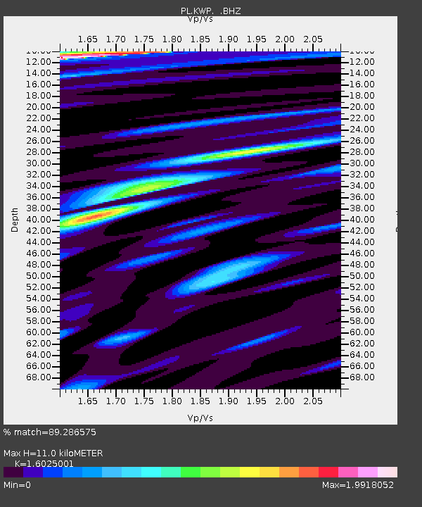
| Estimated Moho Depth: |
11.0 km |
| Estimated Crust Vp/Vs: |
1.60 |
| Assumed Crust Vp: |
6.53 km/s |
| Estimated Crust Vs: |
4.075 km/s |
| Estimated Crust Poisson's Ratio: |
0.18 |
|
| Radial Match: |
89.286575 % |
| Radial Bump: |
400 |
| Transverse Match: |
67.58112 % |
| Transverse Bump: |
400 |
| SOD ConfigId: |
463687 |
| Insert Time: |
2013-02-20 17:12:32.706 +0000 |
| GWidth: |
2.5 |
| Max Bumps: |
400 |
| Tol: |
0.001 |
|

Signal To Noise
| Channel | StoN | STA | LTA |
| PL:KWP: :BHZ:20120629T21:14:53.315994Z | 31.374372 | 4.1879037E-5 | 1.3348167E-6 |
| PL:KWP: :BHN:20120629T21:14:53.287002Z | 5.1310678 | 8.233945E-6 | 1.6047234E-6 |
| PL:KWP: :BHE:20120629T21:14:53.306014Z | 10.550791 | 1.49047255E-5 | 1.4126643E-6 |
| Arrivals |
| Ps | 1.1 SECOND |
| PpPs | 4.1 SECOND |
| PsPs/PpSs | 5.2 SECOND |


