You are here: Home > Network List > G - GEOSCOPE Stations List
> Station SSB Saint Sauveur Badole, France > Earthquake Result Viewer
SSB Saint Sauveur Badole, France - Earthquake Result Viewer
| Earthquake location: |
Kuril Islands |
| Earthquake latitude/longitude: |
44.1/148.1 |
| Earthquake time(UTC): |
1995/04/28 (118) 16:30:00 GMT |
| Earthquake Depth: |
29 km |
| Earthquake Magnitude: |
6.6 MB, 6.9 MS, 7.0 UNKNOWN, 6.8 MW |
| Earthquake Catalog/Contributor: |
WHDF/NEIC |
|
| Network: |
G GEOSCOPE |
| Station: |
SSB Saint Sauveur Badole, France |
| Lat/Lon: |
45.28 N/4.54 E |
| Elevation: |
700 m |
|
| Distance: |
85.3 deg |
| Az: |
335.087 deg |
| Baz: |
25.477 deg |
| Ray Param: |
0.044809494 |
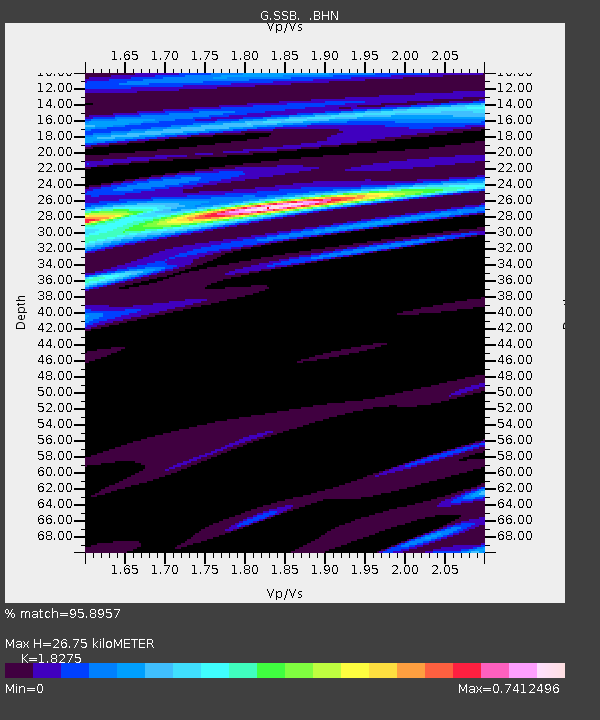
| Estimated Moho Depth: |
26.75 km |
| Estimated Crust Vp/Vs: |
1.83 |
| Assumed Crust Vp: |
6.1 km/s |
| Estimated Crust Vs: |
3.338 km/s |
| Estimated Crust Poisson's Ratio: |
0.29 |
|
| Radial Match: |
95.8957 % |
| Radial Bump: |
307 |
| Transverse Match: |
85.63486 % |
| Transverse Bump: |
400 |
| SOD ConfigId: |
6273 |
| Insert Time: |
2010-02-27 00:09:46.625 +0000 |
| GWidth: |
2.5 |
| Max Bumps: |
400 |
| Tol: |
0.001 |
|

Signal To Noise
| Channel | StoN | STA | LTA |
| G:SSB: :BHN:19950428T16:42:03.650012Z | 23.318188 | 1.9469642E-6 | 8.3495515E-8 |
| G:SSB: :BHE:19950428T16:42:03.650012Z | 10.087267 | 1.1162986E-6 | 1.1066412E-7 |
| G:SSB: :BHZ:19950428T16:42:03.650012Z | 57.423794 | 5.5037785E-6 | 9.584491E-8 |
| Arrivals |
| Ps | 3.7 SECOND |
| PpPs | 12 SECOND |
| PsPs/PpSs | 16 SECOND |


