You are here: Home > Network List > TA - USArray Transportable Network (new EarthScope stations) Stations List
> Station A04D Lummi Island, WA, USA > Earthquake Result Viewer
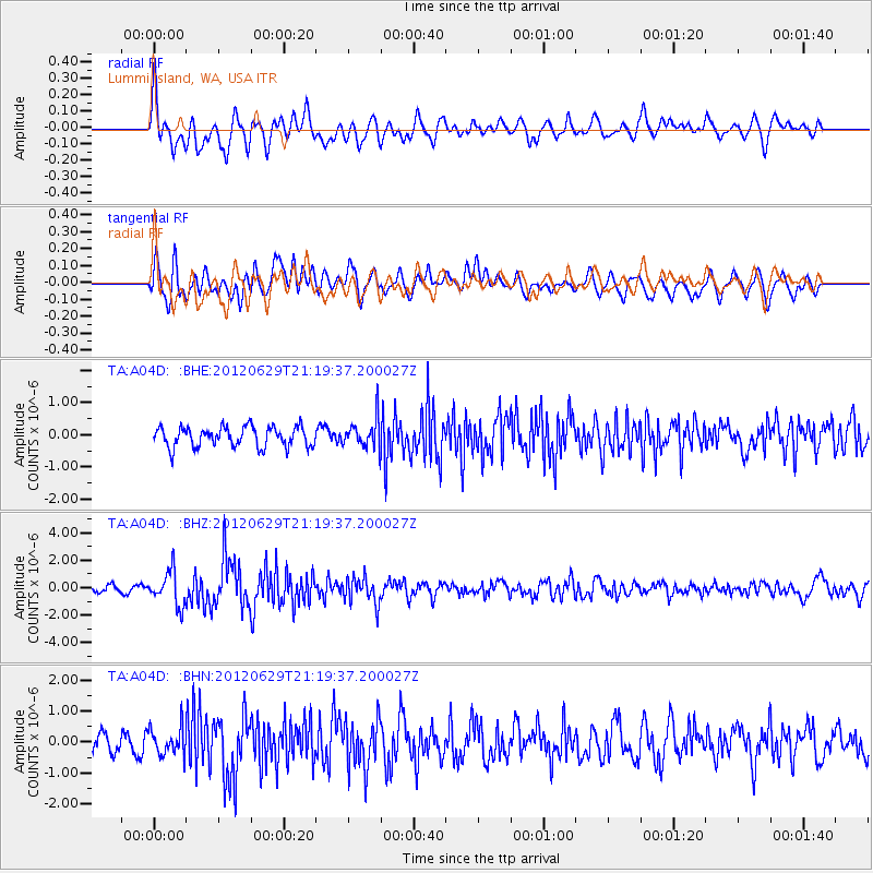
A04D Lummi Island, WA, USA - Earthquake Result Viewer
*The percent match for this event was below the threshold and hence no stack was calculated.
| Earthquake location: |
Northern Xinjiang, China |
| Earthquake latitude/longitude: |
43.4/84.7 |
| Earthquake time(UTC): |
2012/06/29 (181) 21:07:33 GMT |
| Earthquake Depth: |
18 km |
| Earthquake Magnitude: |
6.2 MB, 6.4 MS, 6.3 MW, 6.3 MW |
| Earthquake Catalog/Contributor: |
WHDF/NEIC |
|
| Network: |
TA USArray Transportable Network (new EarthScope stations) |
| Station: |
A04D Lummi Island, WA, USA |
| Lat/Lon: |
48.72 N/122.71 W |
| Elevation: |
13 m |
|
| Distance: |
85.1 deg |
| Az: |
17.814 deg |
| Baz: |
340.334 deg |
| Ray Param: |
$rayparam |
*The percent match for this event was below the threshold and hence was not used in the summary stack. |
|
| Radial Match: |
71.477005 % |
| Radial Bump: |
400 |
| Transverse Match: |
78.262665 % |
| Transverse Bump: |
400 |
| SOD ConfigId: |
463687 |
| Insert Time: |
2013-02-20 17:15:37.436 +0000 |
| GWidth: |
2.5 |
| Max Bumps: |
400 |
| Tol: |
0.001 |
|
Signal To Noise
| Channel | StoN | STA | LTA |
| TA:A04D: :BHZ:20120629T21:19:37.200027Z | 5.460072 | 1.2419398E-6 | 2.2745851E-7 |
| TA:A04D: :BHN:20120629T21:19:37.200027Z | 1.9598925 | 4.3644985E-7 | 2.2269072E-7 |
| TA:A04D: :BHE:20120629T21:19:37.200027Z | 1.4613386 | 4.509613E-7 | 3.0859465E-7 |
| Arrivals |
| Ps | |
| PpPs | |
| PsPs/PpSs | |


