You are here: Home > Network List > G - GEOSCOPE Stations List
> Station SSB Saint Sauveur Badole, France > Earthquake Result Viewer
SSB Saint Sauveur Badole, France - Earthquake Result Viewer
| Earthquake location: |
Northern Peru |
| Earthquake latitude/longitude: |
-3.9/-77.0 |
| Earthquake time(UTC): |
1995/05/02 (122) 06:06:05 GMT |
| Earthquake Depth: |
103 km |
| Earthquake Magnitude: |
6.5 MB, 6.7 UNKNOWN, 6.6 MW |
| Earthquake Catalog/Contributor: |
WHDF/NEIC |
|
| Network: |
G GEOSCOPE |
| Station: |
SSB Saint Sauveur Badole, France |
| Lat/Lon: |
45.28 N/4.54 E |
| Elevation: |
700 m |
|
| Distance: |
86.7 deg |
| Az: |
44.38 deg |
| Baz: |
261.267 deg |
| Ray Param: |
0.04361219 |
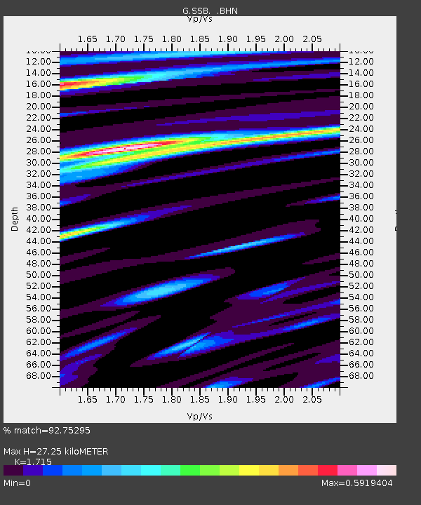
| Estimated Moho Depth: |
27.25 km |
| Estimated Crust Vp/Vs: |
1.72 |
| Assumed Crust Vp: |
6.1 km/s |
| Estimated Crust Vs: |
3.557 km/s |
| Estimated Crust Poisson's Ratio: |
0.24 |
|
| Radial Match: |
92.75295 % |
| Radial Bump: |
305 |
| Transverse Match: |
85.19673 % |
| Transverse Bump: |
400 |
| SOD ConfigId: |
6273 |
| Insert Time: |
2010-02-27 00:09:54.020 +0000 |
| GWidth: |
2.5 |
| Max Bumps: |
400 |
| Tol: |
0.001 |
|
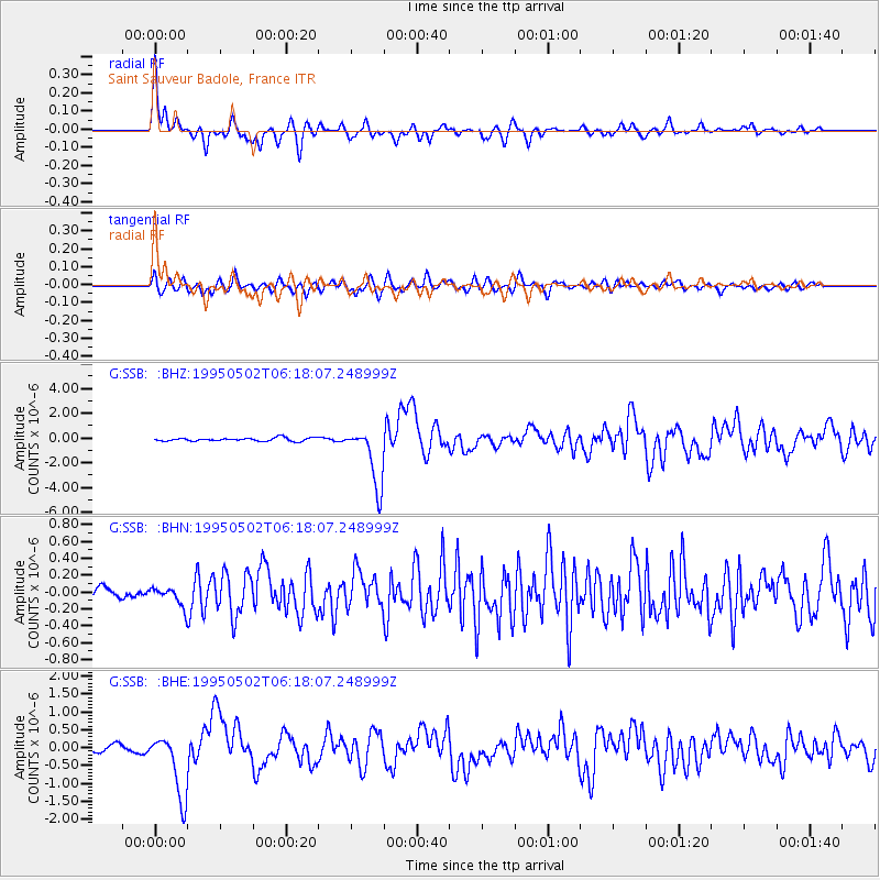
Signal To Noise
| Channel | StoN | STA | LTA |
| G:SSB: :BHN:19950502T06:18:07.248999Z | 1.1519852 | 1.1099349E-7 | 9.634976E-8 |
| G:SSB: :BHE:19950502T06:18:07.248999Z | 10.12238 | 8.984925E-7 | 8.876297E-8 |
| G:SSB: :BHZ:19950502T06:18:07.248999Z | 18.363302 | 2.417175E-6 | 1.3163074E-7 |
| Arrivals |
| Ps | 3.3 SECOND |
| PpPs | 12 SECOND |
| PsPs/PpSs | 15 SECOND |


