You are here: Home > Network List > TA - USArray Transportable Network (new EarthScope stations) Stations List
> Station C33A Trail, MN, USA > Earthquake Result Viewer
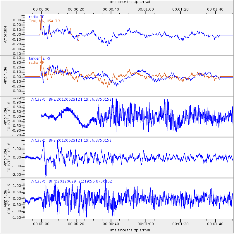
C33A Trail, MN, USA - Earthquake Result Viewer
*The percent match for this event was below the threshold and hence no stack was calculated.
| Earthquake location: |
Northern Xinjiang, China |
| Earthquake latitude/longitude: |
43.4/84.7 |
| Earthquake time(UTC): |
2012/06/29 (181) 21:07:33 GMT |
| Earthquake Depth: |
18 km |
| Earthquake Magnitude: |
6.2 MB, 6.4 MS, 6.3 MW, 6.3 MW |
| Earthquake Catalog/Contributor: |
WHDF/NEIC |
|
| Network: |
TA USArray Transportable Network (new EarthScope stations) |
| Station: |
C33A Trail, MN, USA |
| Lat/Lon: |
47.76 N/95.77 W |
| Elevation: |
388 m |
|
| Distance: |
89.2 deg |
| Az: |
0.319 deg |
| Baz: |
359.656 deg |
| Ray Param: |
$rayparam |
*The percent match for this event was below the threshold and hence was not used in the summary stack. |
|
| Radial Match: |
75.509155 % |
| Radial Bump: |
400 |
| Transverse Match: |
44.687206 % |
| Transverse Bump: |
400 |
| SOD ConfigId: |
463687 |
| Insert Time: |
2013-02-20 17:16:14.473 +0000 |
| GWidth: |
2.5 |
| Max Bumps: |
400 |
| Tol: |
0.001 |
|
Signal To Noise
| Channel | StoN | STA | LTA |
| TA:C33A: :BHZ:20120629T21:19:56.875015Z | 9.538903 | 8.8289033E-7 | 9.2556796E-8 |
| TA:C33A: :BHN:20120629T21:19:56.875015Z | 2.9523027 | 4.43751E-7 | 1.5030673E-7 |
| TA:C33A: :BHE:20120629T21:19:56.875015Z | 1.13256 | 3.3106627E-7 | 2.9231677E-7 |
| Arrivals |
| Ps | |
| PpPs | |
| PsPs/PpSs | |


