You are here: Home > Network List > TA - USArray Transportable Network (new EarthScope stations) Stations List
> Station C38A Sawbill Landing (USFS), Superior Nat. Forest, MN, > Earthquake Result Viewer
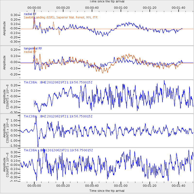
C38A Sawbill Landing (USFS), Superior Nat. Forest, MN, - Earthquake Result Viewer
*The percent match for this event was below the threshold and hence no stack was calculated.
| Earthquake location: |
Northern Xinjiang, China |
| Earthquake latitude/longitude: |
43.4/84.7 |
| Earthquake time(UTC): |
2012/06/29 (181) 21:07:33 GMT |
| Earthquake Depth: |
18 km |
| Earthquake Magnitude: |
6.2 MB, 6.4 MS, 6.3 MW, 6.3 MW |
| Earthquake Catalog/Contributor: |
WHDF/NEIC |
|
| Network: |
TA USArray Transportable Network (new EarthScope stations) |
| Station: |
C38A Sawbill Landing (USFS), Superior Nat. Forest, MN, |
| Lat/Lon: |
47.72 N/91.27 W |
| Elevation: |
498 m |
|
| Distance: |
89.2 deg |
| Az: |
357.282 deg |
| Baz: |
2.933 deg |
| Ray Param: |
$rayparam |
*The percent match for this event was below the threshold and hence was not used in the summary stack. |
|
| Radial Match: |
72.65618 % |
| Radial Bump: |
400 |
| Transverse Match: |
50.887314 % |
| Transverse Bump: |
400 |
| SOD ConfigId: |
463687 |
| Insert Time: |
2013-02-20 17:17:18.044 +0000 |
| GWidth: |
2.5 |
| Max Bumps: |
400 |
| Tol: |
0.001 |
|
Signal To Noise
| Channel | StoN | STA | LTA |
| TA:C38A: :BHZ:20120629T21:19:56.750015Z | 7.0278893 | 7.5566066E-7 | 1.0752313E-7 |
| TA:C38A: :BHN:20120629T21:19:56.750015Z | 2.0302808 | 1.7767951E-7 | 8.751475E-8 |
| TA:C38A: :BHE:20120629T21:19:56.750015Z | 1.0081205 | 1.138898E-7 | 1.129724E-7 |
| Arrivals |
| Ps | |
| PpPs | |
| PsPs/PpSs | |


