You are here: Home > Network List > XR12 - Deployment of a simultaneous broadband gradiometers to quantify the effects of a Stations List
> Station EC01 Lincolnton, GA > Earthquake Result Viewer
EC01 Lincolnton, GA - Earthquake Result Viewer
| Earthquake location: |
Aegean Sea |
| Earthquake latitude/longitude: |
40.3/25.5 |
| Earthquake time(UTC): |
2014/05/24 (144) 09:25:03 GMT |
| Earthquake Depth: |
10 km |
| Earthquake Magnitude: |
6.4 MWP, 6.4 M |
| Earthquake Catalog/Contributor: |
NEIC PDE/NEIC ALERT |
|
| Network: |
XR Deployment of a simultaneous broadband gradiometers to quantify the effects of a |
| Station: |
EC01 Lincolnton, GA |
| Lat/Lon: |
33.78 N/82.49 W |
| Elevation: |
151 m |
|
| Distance: |
80.8 deg |
| Az: |
306.597 deg |
| Baz: |
47.48 deg |
| Ray Param: |
0.048052922 |
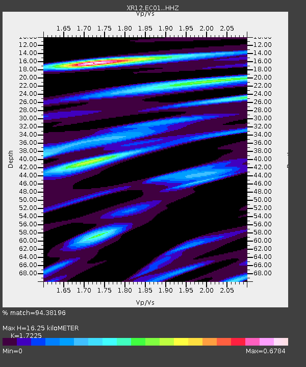
| Estimated Moho Depth: |
16.25 km |
| Estimated Crust Vp/Vs: |
1.72 |
| Assumed Crust Vp: |
6.565 km/s |
| Estimated Crust Vs: |
3.811 km/s |
| Estimated Crust Poisson's Ratio: |
0.25 |
|
| Radial Match: |
94.38196 % |
| Radial Bump: |
294 |
| Transverse Match: |
77.8355 % |
| Transverse Bump: |
400 |
| SOD ConfigId: |
3390531 |
| Insert Time: |
2019-04-12 00:49:08.957 +0000 |
| GWidth: |
2.5 |
| Max Bumps: |
400 |
| Tol: |
0.001 |
|

Signal To Noise
| Channel | StoN | STA | LTA |
| XR:EC01: :HHZ:20140524T09:36:45.459985Z | 4.8044243 | 3.1042092E-7 | 6.461147E-8 |
| XR:EC01: :HHN:20140524T09:36:45.459985Z | 1.2672018 | 7.948076E-8 | 6.272147E-8 |
| XR:EC01: :HHE:20140524T09:36:45.459985Z | 2.543589 | 1.8543587E-7 | 7.2903234E-8 |
| Arrivals |
| Ps | 1.8 SECOND |
| PpPs | 6.5 SECOND |
| PsPs/PpSs | 8.4 SECOND |


