You are here: Home > Network List > G - GEOSCOPE Stations List
> Station SSB Saint Sauveur Badole, France > Earthquake Result Viewer
SSB Saint Sauveur Badole, France - Earthquake Result Viewer
| Earthquake location: |
Taiwan Region |
| Earthquake latitude/longitude: |
21.9/121.5 |
| Earthquake time(UTC): |
1996/09/05 (249) 23:42:06 GMT |
| Earthquake Depth: |
20 km |
| Earthquake Magnitude: |
6.4 MB, 6.6 MS, 6.8 UNKNOWN, 6.8 ME |
| Earthquake Catalog/Contributor: |
WHDF/NEIC |
|
| Network: |
G GEOSCOPE |
| Station: |
SSB Saint Sauveur Badole, France |
| Lat/Lon: |
45.28 N/4.54 E |
| Elevation: |
700 m |
|
| Distance: |
92.0 deg |
| Az: |
320.971 deg |
| Baz: |
55.925 deg |
| Ray Param: |
0.0415234 |
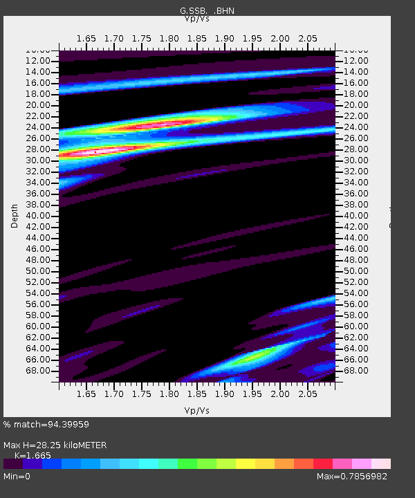
| Estimated Moho Depth: |
28.25 km |
| Estimated Crust Vp/Vs: |
1.66 |
| Assumed Crust Vp: |
6.1 km/s |
| Estimated Crust Vs: |
3.664 km/s |
| Estimated Crust Poisson's Ratio: |
0.22 |
|
| Radial Match: |
94.39959 % |
| Radial Bump: |
400 |
| Transverse Match: |
84.81951 % |
| Transverse Bump: |
400 |
| SOD ConfigId: |
6273 |
| Insert Time: |
2010-02-27 00:10:01.661 +0000 |
| GWidth: |
2.5 |
| Max Bumps: |
400 |
| Tol: |
0.001 |
|
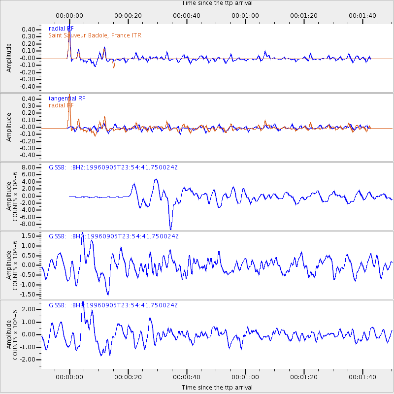
Signal To Noise
| Channel | StoN | STA | LTA |
| G:SSB: :BHN:19960905T23:54:41.750024Z | 4.932949 | 8.0734907E-7 | 1.6366458E-7 |
| G:SSB: :BHE:19960905T23:54:41.750024Z | 3.7731717 | 1.1398291E-6 | 3.0208778E-7 |
| G:SSB: :BHZ:19960905T23:54:41.750024Z | 4.2134995 | 4.1477347E-6 | 9.843919E-7 |
| Arrivals |
| Ps | 3.1 SECOND |
| PpPs | 12 SECOND |
| PsPs/PpSs | 15 SECOND |


